AP Human Geography Unit 5: Agricultural Origins and Rural Landscapes
Unit 5: Agriculture and Rural Land-Use Patterns and Processes
Introduction to Agriculture
Defining Agriculture
Agriculture is the deliberate modification of Earth’s surface through the cultivation of plants and rearing of animals to obtain sustenance or economic gain. It is perhaps the most significant transformation of the environment in human history.
Before the invention of agriculture, humans practiced Hunting and Gathering. This lifestyle relied on collecting wild plants and hunting wild animals. Today, less than 0.005% of the world's population still practices hunting and gathering (e.g., the Sentinelese in the Andaman Islands or the San people of Southern Africa).
The First Agricultural Revolution (Neolithic Revolution)
Looking back roughly 10,000 to 12,000 years ago, the First Agricultural Revolution marked the transition from hunting and gathering to settled farming. This shift allowed for:
- Sedentary living: Humans began staying in one place.
- Population growth: Stable food supplies supported larger populations.
- Social stratification: Surplus food allowed some people to specialize in non-farming tasks (artisans, leaders, soldiers).
Settlement Patterns and Survey Methods
How people organize themselves on the land tells us a lot about their culture, history, and geography. In rural areas, settlement diagrams generally fall into three categories.
Rural Settlement Patterns
- Clustered Settlements (Nucleated):
- Houses and farm buildings are grouped closely together, often around a central feature like a church, pub, or village green.
- Context: Common in Europe. Historically used for defense against invaders and to reinforce communal unity. Fields surround the settlement.
- Dispersed Settlements:
- Farms are isolated and spread far apart from one another.
- Context: Common in the North American Midwest. This pattern often signifies a focus on individual land ownership and large-scale, mechanized farming.
- Linear Settlements:
- Buildings follow a line, typically along a road, river, or coastline.
- Context: Facilitates transportation and communication. Often seen in low-lying areas in Western Europe or along rivers in Quebec.
Rural Survey Methods
Distinct methods of measuring and dividing land reflect the society that implemented them. You must be able to identify these visually.
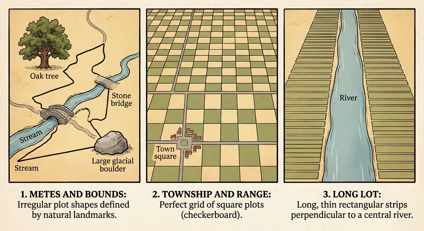
1. Metes and Bounds
- Origin: Great Britain.
- Description: Uses physical features of the local geography (trees, rocks, streams) to define boundaries. The shapes are often irregular and "messy."
- Region: Found in the original 13 Colonies of the United States.
2. Township and Range
- Origin: United States Land Ordinance of 1785 (promoted by Thomas Jefferson).
- Description: A geometric rigid grid system. It divides land into 6x6 mile square Townships, which are further divided into 1x1 mile Sections.
- Region: Dominant in the U.S. Midwest and West. This creates the "checkerboard" pattern seen when flying over the central US.
3. Long Lot System
- Origin: French and Spanish influence.
- Description: Narrow lots perpendicular to a river or road. This ensures every farmer has access to water transport or the main road.
- Region: Quebec (Canada), Louisiana (USA), and parts of Texas.
| Survey System | Key Characteristic | Typical Region |
|---|---|---|
| Metes & Bounds | Irregular, natural landmarks | US East Coast (13 Colonies) |
| Township & Range | Geometric Grid (Squares) | US Midwest/West |
| Long Lot | Long, narrow strips | Quebec, Louisiana |
Agricultural Origins and Diffusions
centers of Origin (Hearths)
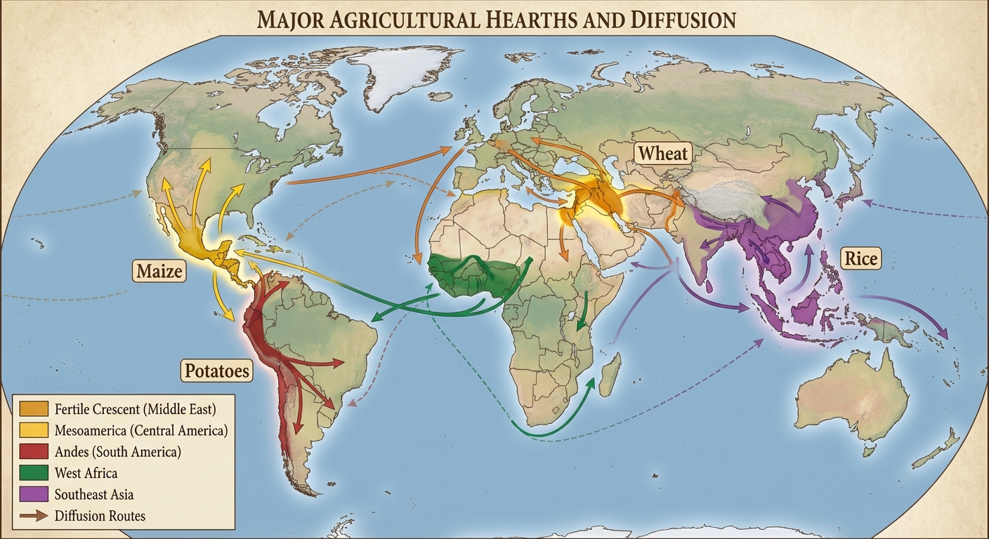
Geographer Carl Sauer was a pioneer in identifying agricultural hearths (centers of innovation). He distinguished between Vegetative Planting (cloning plants by cutting roots/stems) and Seed Agriculture (planting seeds, which came later).
Important Hearths and their crops:
- Fertile Crescent (Southwest Asia):
- Crops: Wheat, Barley, Oats, Lentils.
- Animals: Sheep, Goats, Cattle, Pigs. (This is the hearth of the most important herd animals).
- Southeast Asia:
- Crops: Mango, Taro, Coconut.
- Note: Likely the hearth of vegetative planting.
- East Asia:
- Crops: Rice, Soybeans.
- Sub-Saharan Africa:
- Crops: Yams, Sorghum, Coffee.
- Mesoamerica (Central America):
- Crops: Maize (Corn), Beans, Squash, Cotton.
- Note: Maize is the most important crop from this region.
- Andean Region (South America):
- Crops: Potatoes.
The Columbian Exchange
The Columbian Exchange began in the late 15th century (post-1492) and resulted in the global diffusion of plants, animals, and diseases between the Americas (New World) and Europe/Africa/Asia (Old World).
- To the Americas (introduced): Wheat, Cattle, Sheep, Horses, Pigs, Smallpox, Measles.
- To Europe/Afro-Eurasia (introduced): Maize (Corn), Potatoes, Tomatoes, Tobacco, Turkeys, Syphilis.
Impact: The introduction of the potato to Europe spurred massive population growth (calorically dense food source). The introduction of the horse transformed Indigenous cultures in the North American Great Plains.
The Second Agricultural Revolution
While the First Revolution created farming, the Second Agricultural Revolution industrialized it. This occurred roughly between 1700 and 1900, coinciding with the Industrial Revolution.
Key Causes and Innovations
The British Enclosure Acts:
- Governments consolidated small strips of land owned by peasants into large, fenced-in fields owned by wealthy individuals.
- Result: Small farmers were displaced and moved to cities (providing the labor force for the Industrial Revolution). Farm efficiency skyrocketed because wealthy owners could experiment with new techniques.
Mechanization and Technology:
- Jethro Tull’s Seed Drill: Allowed farmers to plant seeds in rows and at specific depths rather than scattering them randomly (broadcasting). This increased germination rates.
- Steel Plow: Allowed for the cultivation of tougher soils.
Crop Rotation:
- Systematic rotation of crops in a field (e.g., the Norfolk four-course system). Planting clover or turnips replenished soil nutrients (nitrogen) that wheat had depleted, eliminating the need to leave fields fallow (empty/resting).
Effects on Demographics
- Diet and Health: Higher food output and better preservation led to better diets and longer life expectancies.
- The J-Curve: This revolution helped launch the global population explosion (Stage 2 of the Demographic Transition Model).
- Urbanization: Fewer farmers were needed to feed more people, causing a massive migration from rural areas to urban centers.
Common Mistakes & Pitfalls
Confusing the Revolutions:
- Mistake: Thinking the Green Revolution happened in the 1800s.
- Correction:
- 1st Rev: Neolithic (10,000 BCE) -> Hunting to Farming.
- 2nd Rev: Industrial (1700s-1800s) -> Mechanization/Enclosure acts.
- 3rd Rev (Green): Modern (1960s-Present) -> GMOs, Chemical Fertilizers.
Misidentifying Origins:
- Mistake: Assuming Potatoes are from Ireland or Tomatoes are from Italy.
- Correction: Both Potatoes and Tomatoes are from the Americas (New World). They only became staples in Europe after the Columbian Exchange.
Township and Range:
- Mistake: Thinking Township and Range is determined by physical features.
- Correction: Township and Range is a geometric grid strictly based on measurements, ignoring physical terrain. Metes and Bounds relies on physical features.