Unit 6 Comprehensive Review: Urban Systems and Spatial Patterns
The Size and Distribution of Cities
Before understanding the inside of a city, geographers look at how cities represent specific patterns across a country or region. There are two primary theories used to describe the hierarchy of settlements.
Rank-Size Rule
Common in developed countries with federal governments and diverse economies (e.g., United States, Canada, Germany), the Rank-Size Rule suggests a predictable mathematical relationship between the population of a city and its rank in the urban hierarchy.
The formula usually states that the $n$-th largest city will be $\frac{1}{n}$ the size of the largest city.
- Formula:
- Where $P_n$ is the population of the city at rank $n$.
- Where $P_1$ is the population of the largest city.
- Example: If the largest city has 10 million people:
- The 2nd largest city has 5 million ($1/2$).
- The 4th largest city has 2.5 million ($1/4$).
- Implications: Indicates a sufficiently wealthy society where goods and services are well-distributed throughout the country.
The Primate City Rule
A Primate City is a city that is more than twice as large as the next largest city and is the overwhelming center of the nation's political, cultural, and economic life.
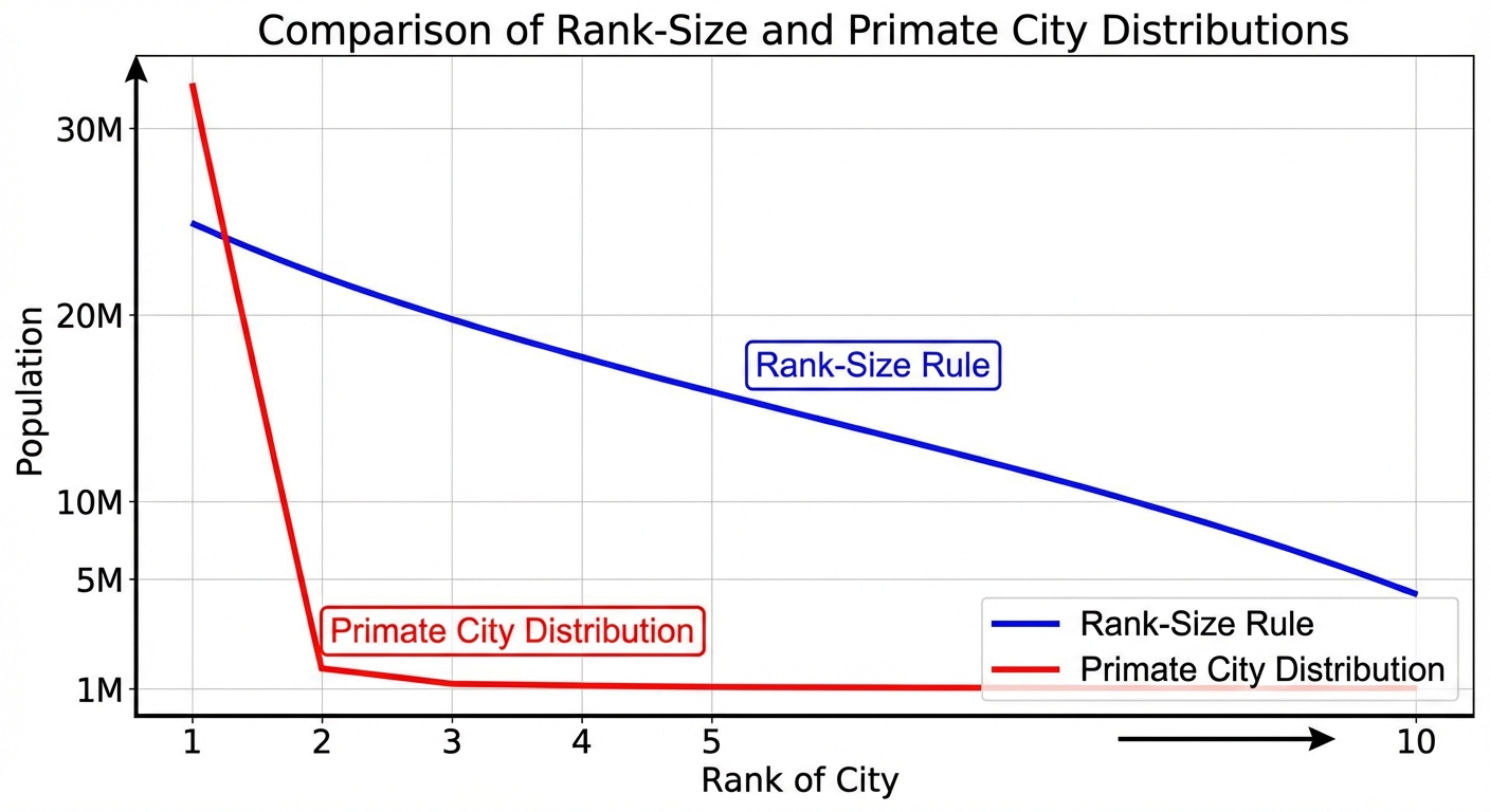
- Characteristics:
- Often found in Unitary states or Less Developed Countries (LDCs).
- Often a former colonial hub.
- Examples: Mexico City (Mexico), Paris (France), London (UK), Bangkok (Thailand).
- Pros: Agglomeration of services allows for a strong central economy; easier global integration.
- Cons: Uneven development; the countryside (periphery) is often neglected as resources drain into the primate city.
The Gravity Model
Derived from physics, the Gravity Model predicts the degree of interaction between two places.
- Concept: Interaction is directly related to population size and inversely related to distance.
- Application: Big cities (NYC and LA) interact more with each other—despite the distance—than a small town interacts with another small town near it, due to the volume of specialized services and flows of capital.
The Internal Structure of Cities (Land Use Models)
Classical North American Models
These models attempt to explain where people live and work based on historical transportation and economic trends.
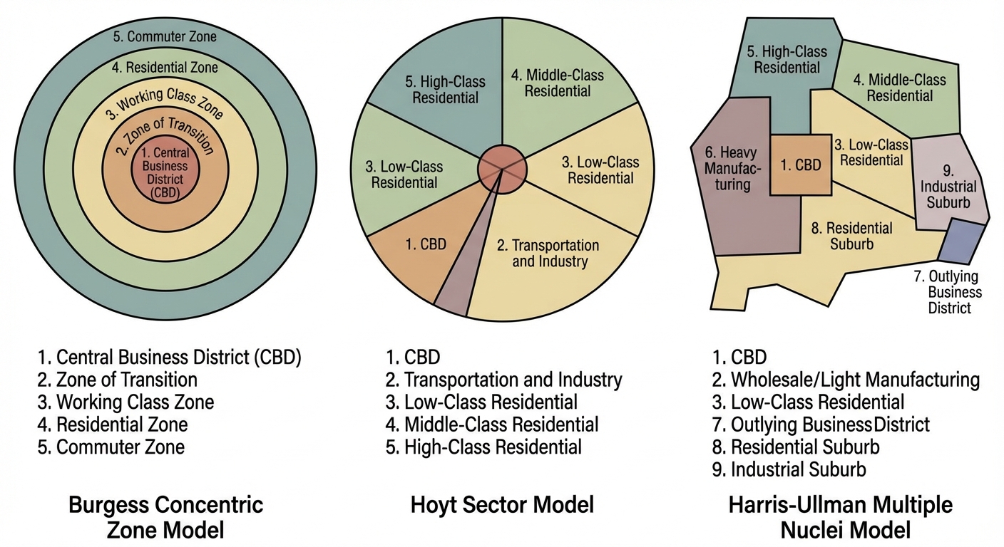
Concentric Zone Model (Burgess)
- Basis: 1920s Chicago; based on walking/horse transportation.
- Structure: A series of rings. The CBD (Central Business District) is the center. As you move outward, housing gets newer and wealthier.
- Invasion and Succession: New immigrants move into the inner rings (transition zone), pushing established residents outward.
Sector Model (Hoyt)
- Basis: 1930s; based on rail lines and trolley cars.
- Structure: Wedges (sectors) radiating from the center. Industrial zones follow rail lines; high-income housing follows scenic routes or high ground relative to the CBD.
Multiple Nuclei Model (Harris & Ullman)
- Basis: 1940s; emerging car culture.
- Structure: The CBD loses dominance. Cities have multiple "nodes" of activity (e.g., a university node, an airport node, a medical center node). Compatible land uses cluster (bookstores near universities), while incompatible ones repel (heavy industry away from wealthy housing).
Galactic City (Peripheral) Model
- Basis: Post-1950s; highway/beltway dominance.
- Structure: A decentralized city surrounded by a beltway highway.
- Key Term: Edge Cities. These are suburban hubs on the beltway that have their own office parks, retail, and entertainment, emerging as rivals to the traditional CBD.
International City Models
Urban structure varies globally due to history (colonialism) and culture.
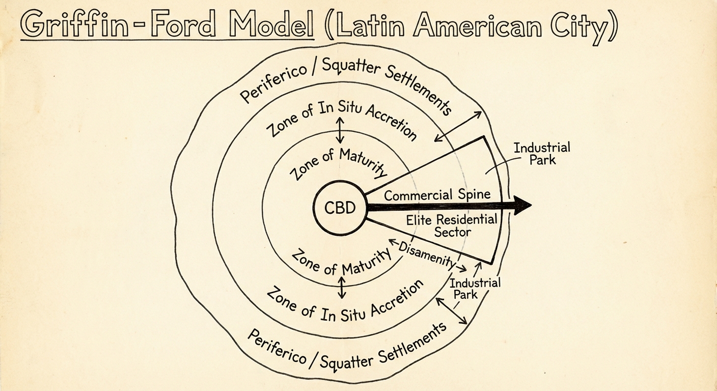
- Latin American City Model (Griffin-Ford):
- Features a Spine of high-end commercial development extending from the CBD, surrounded by elite residential sectors.
- The periphery contains Squatter Settlements (favelas/barriadas) where the poorest residents live, often with limited infrastructure.
- Contrast: In the US, the poor often live near the center (inner city); in Latin America, they live on the outskirts.
- African City Model (De Blij):
- Features three CBDs: Colonial (administrative), Traditional (market), and Market Zone (open-air commerce).
- Neighborhoods are often divided by ethnicity/tribe.
- Southeast Asian City Model (McGee):
- Focus is on the Port Zone (no formal CBD).
- Western commercial zones and alien (Chinese) commercial zones cluster near the port.
Density and Land Use
Bid-Rent Theory
This economic theory explains how land value and land use change as you move away from the central market (CBD).
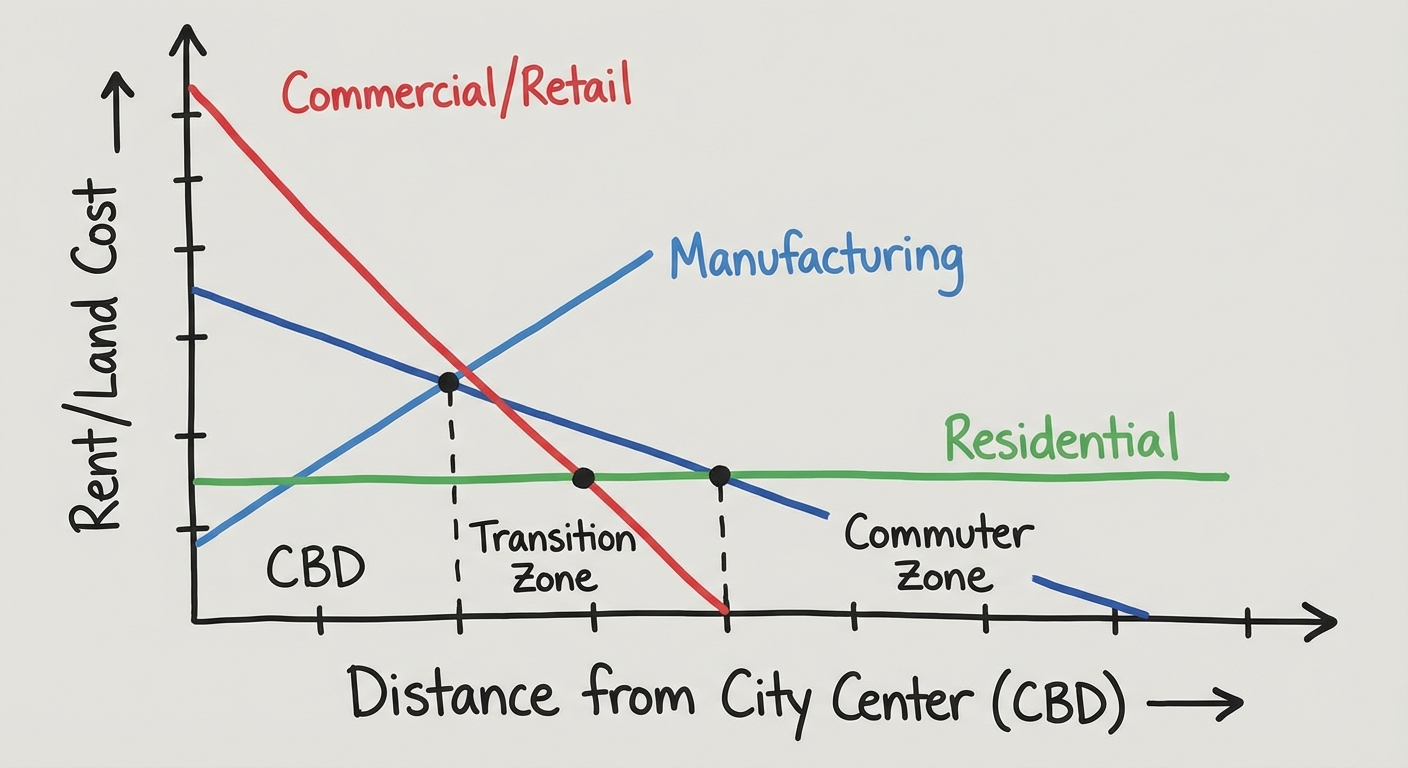
- The Rule: Land users compete for the most accessible land (the center).
- Price: Land price is highest at the center.
- Application:
- Commercial (Retail): Needs high foot traffic, willing to pay high rent ( Bid). Located in CBD.
- Manufacturing: Needs space but access to transport. Pays moderate rent.
- Residential: Individuals cannot afford CBD prices. They trade accessibility for space further out.
- Result: This creates high-density vertical building in the CBD and low-density single-family homes in the suburbs.
Urban Sustainability and Challenges
Changing Urban Demographics
Historical Housing Discrimination
Many modern US urban challenges stem from mid-20th-century policies:
- Redlining: Banks refusing loans to people in certain ("redlined") areas, usually Black neighborhoods, leading to decay.
- Blockbusting: Real estate agents inducing fear of racial change to convince white homeowners to sell low, then selling high to minority families (White Flight).
Gentrification
This is the process of middle-class/wealthy people moving into deteriorated inner-city neighborhoods and renovating housing.
- Pros: Increases tax base, improves infrastructure, reduces crime, revitalizes buildings.
- Cons: Increases rent/property taxes, displacing low-income original residents; erodes local cultural character.
Urban Sprawl vs. Sustainability
Urban Sprawl
- Unrestricted growth of housing, commercial developments, and roads over large expanses of land, with little concern for urban planning.
- Negative Impacts: High reliance on cars (emissions), loss of arable farmland, "placelessness" (cookie-cutter suburbs).
Smart Growth & New Urbanism
- Movements to combat sprawl primarily in the US and Europe.
- Smart Growth: Government regulations (Urban Growth Boundaries) to limit sprawl and preserve farmland.
- New Urbanism: A design philosophy focusing on:
- Walkability: Pedestrian-friendly streets.
- Mixed-Use Development: Residential and commercial in the same building (shops on bottom, apartments on top).
- Transit-Oriented Development: Building dense housing near subways/light rail.
Brownfields vs. Greenfields
- Brownfields: Abandoned industrial sites (factories) that are cleaned up and redeveloped (Sustainable).
- Greenfields: Undeveloped land (farms/forests) built upon for the first time (Contributes to sprawl).
Common Mistakes & Pitfalls
- Mistake 1: Confusing Rank-Size with Population Density.
- Correction: Rank-Size focuses on the hierarchy of city sizes (1st vs 2nd vs 3rd), NOT how crowded a single city is.
- Mistake 2: Assuming all cities follow the Concentric Zone.
- Correction: Most modern cities are Galactic/Multiple Nuclei. The Concentric Zone is a historical model (1920s) and rarely applies perfectly today.
- Mistake 3: Mixing up "Squatter Settlements" location.
- Correction: Remember this rule: In rich countries (US/Europe), the poor are generally in the inner city (older housing). In developing countries (Latin America/Africa), the poor are generally in the periphery (squatter settlements) because they cannot afford legal housing near the center.