AP Human Geography: Unit 4 Review Notes
Introduction to Political Geography
Political geography helps us understand how the human desire to control territory defines our world. At its core, this field examines how humans divide Earth into territories, how those territories are governed, and how people relate to them.
The Concept of Territoriality
Territoriality is the connection of people to their culture, and their economic systems to the land. It expresses a desire for ownership and sovereignty over a defined space. This is not just about ownership of land, but the power to control what happens within it.
Sovereignty and Legitimacy
For a political unit to function on the global stage, it requires sovereignty. This is the right of a government to control and defend its territory and determine what happens within its borders without interference from outside forces.
In the modern geopolitical landscape, sovereignty implies international recognition. A place may function like an independent country (e.g., Taiwan in many respects), but without full international recognition of its sovereignty, its status remains contested.
Types of Political Entities
Students often use terms like "country" and "nation" interchangeably, but in AP Human Geography, the distinction is crucial.
The Hierarchy of Political Units
State:
This is the formal term for a "country." To be a state, an entity must have:- A defined territory (borders).
- A permanent population.
- A government capable of maintaining order.
- Sovereignty (recognition from other states).
- Examples: France, Canada, Nigeria.
Nation:
A culturally defined group of people with a shared past and a common future who relate to a territory and government. A nation is people-centric, whereas a state is land/politics-centric.- Key factors: Shared language, religion, ethnicity, and history.
- Example: The Han Chinese, the Kurds, the Japanese people.
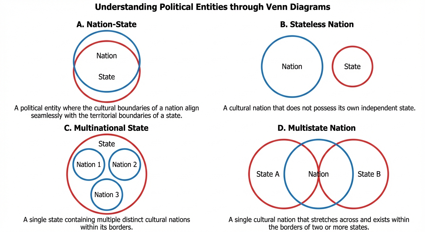
Nation-State:
The ideal political unit where the geographic boundaries of the state correspond almost exactly to the geographic boundaries of a nation. The population is ethnically homogenous.- Examples: Iceland and Japan are the classic examples. No state is 100% pure, but these are very close.
Complex Political Arrangements
Most of the world does not fit the perfect "Nation-State" mold. We categorize these complexities as follows:
- Multinational State: A state that contains more than one nation. The nations may coexist peacefully or face distinct challenges (centrifugal forces).
- Example: The United Kingdom (English, Scottish, Welsh, Northern Irish) or Russia.
- Multistate Nation: A nation (group of people) that stretches across the borders of two or more states.
- Example: Koreans (spread across North and South Korea) or Hungarians (living in Hungary and Romania).
- Stateless Nation: A nation without a state. These groups often seek self-determination (the right to govern themselves).
- Example: The Kurds (spread across Turkey, Iraq, Iran, Syria) and the Palestinians.
- Autonomous & Semi-Autonomous Regions: Defined areas within a state that have a high degree of self-government and freedom from the parent state.
- Example: Hong Kong (China) or Native American Reservations (USA).
Defining Political Boundaries
Boundaries are not just lines in the sand; they are vertical planes that cut through the subsoil below and the airspace above.
The Evolution of a Boundary
Creating a border usually follows four steps:
- Definition: A treaty or legal document is drawn up to establish points in the landscape.
- Delimitation: Cartographers draw the line on a map.
- Demarcation: Markers are placed on the ground (walls, fences, pillars). This step is expensive and not always done.
- Administration: The government determines how the boundary will be maintained and how people/goods will cross it.
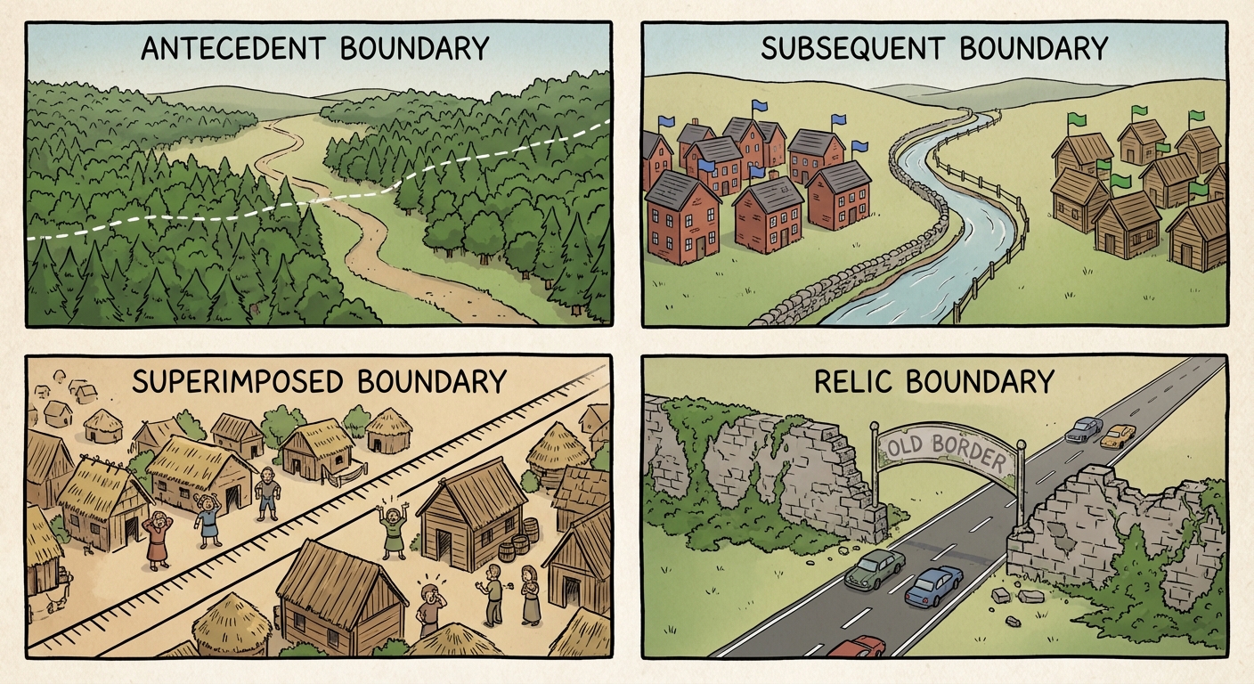
Classifying Boundaries by Origin
| Type | Definition | Example |
|---|---|---|
| Antecedent | Drawn before a large population was present or the cultural landscape emerged. | The US-Canada border (49th parallel) in the West; Malaysia-Indonesia border. |
| Subsequent | Drawn after settlement; usually meant to accommodate cultural, religious, or linguistic differences. | Northern Ireland & Ireland; boundaries in the Balkans after Yugoslavia. |
| Superimposed | Forced on an area by an outside conquering power, ignoring existing cultural patterns. | The Berlin Conference (1884) borders in Africa. |
| Relic | No longer functions as a border but still leaves a visual imprint on the landscape. | The Berlin Wall; The Great Wall of China; North/South Vietnam. |
Classifying Boundaries by Form
- Geometric: Straight lines drawn on a map (often using latitude/longitude), unrelated to physical features. (e.g., The 1300-mile straight line between the US and Canada).
- Physical-Political (Natural): Based on physical features like mountains, rivers, or deserts. (e.g., The Rio Grande between the US and Mexico; the Pyrenees between Spain and France).
The Function of Political Boundaries
Boundaries serve to limit jurisdiction, but they also act as filters for economic interaction.
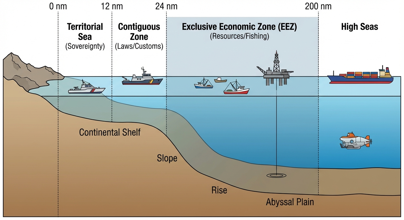
The Law of the Sea (UNCLOS)
The United Nations Convention on the Law of the Sea (UNCLOS) standardized territorial claims in the ocean. This is critical for understanding modern geopolitical conflicts (like in the South China Sea).
- Territorial Sea (0–12 nautical miles):
- Coastal state has total sovereignty. Commercial vessels may pass, but non-commercial (military) may be challenged.
- Contiguous Zone (12–24 nautical miles):
- State can enforce laws regarding customs, immigration, and sanitation. (e.g., pursuing drug smugglers).
- Exclusive Economic Zone (EEZ) (Up to 200 nautical miles):
- State has the sole right to explore, exploit, and manage natural resources (fish, oil, gas) in the water and seabed.
- High Seas (International Waters):
- Water beyond the EEZ is open to all states.
The Median Line Principle: If two states are less than 400 nautical miles apart (preventing a full 200nm EEZ for both), the boundary is typically drawn exactly halfway between them.
Boundary Disputes
When boundaries fail or are contested, conflict arises. We categorize these disputes by their nature:
- Definitional: Dispute over the legal language of the treaty (e.g., "Does the border run down the middle of the river or the bank?").
- Locational: Dispute over where the line is delimited or demarcated on the ground.
- Operational: Dispute over the function of the border (e.g., migration migration policies).
- Allocational: Dispute over resources that cross the border (e.g., oil fields, aquifers, or water rights).
Common Mistakes & Pitfalls
Nation vs. State:
- Mistake: Using "State" to refer to provinces (like Texas or California). In AP Human Geo, "State" almost always means a sovereign country.
- Correction: Remember: State = Country. Nation = People.
The United Kingdom is a Multinational State:
- Mistake: Thinking the UK is a single nation-state.
- Correction: The UK is a state containing the nations of England, Scotland, Wales, and Northern Ireland.
EEZ vs. Territorial Sea:
- Mistake: Thinking a country has full legal power in its EEZ.
- Correction: In the EEZ (12-200nm), they only own the resources. They cannot stop a Chinese ship from sailing through their EEZ, but they can stop them from fishing there.
Delimitation vs. Demarcation:
- Mistake: Using these interchangeably.
- Correction: Delimitation is drawing it on a map; Demarcation is building a physical structure (fence/wall).