Tropical Atmosphere Test 1
0.0(0)
Studied by 1 personCard Sorting
1/46
Earn XP
Description and Tags
Last updated 2:22 PM on 9/11/22
Name | Mastery | Learn | Test | Matching | Spaced | Call with Kai | Chat |
|---|
No analytics yet
Send a link to your students to track their progress
47 Terms
1
New cards
Edmund Halley
1686, had a theory for the NE and SE trade winds that the winds were the result of cool dense air flowing to a region of hot air, then rises
2
New cards
George Hadley
1735, proposed a single axisymmetric cell in each hemisphere that transports heat from the tropics to the poles
3
New cards
Lord Kelvin
1857 & 1892, presented a more complex near surface complication but retained the single "Hadley cell" circulation aloft
4
New cards
Where is the Hadley circulation confirmed?
Between the equator and subtropics, plus/minus 30deg
5
New cards
William Ferrel
1856-1861, proposed midlatitude circulation cells with westerly winds were caused by air deflected by the Coriolis force
6
New cards
What causes the subtropical jet at 30deg lat?
air flowing upward and poleward in the Hadley cell
7
New cards
Trade winds
lowest branch of the Hadley cells that play a significant role in shaping the weather and ocean interactions in the tropics
8
New cards
Tropical Easterly Jet
9
New cards
What controls the subtropics and stj?
angular momentum conservation
10
New cards
Main reasons for existing global circulation pattern
earth's rotation, atmospheric gases change density in response to temperature changes, topography of earth, unequal heating of earth
11
New cards
what jet stream has substantial influence on south asian monsoon weather
tropical easterly
12
New cards
barotropic
tropospheric atmosphere! A situation that results in upper-level weather maps having height contours and isotherms parallel to each other.
13
New cards
baroclinic
midlatitude atmosphere! A situation that results in upper-level weather maps having height contours and isotherms that intersect each other. This situation may enhance or reduce upper-level divergence or convergence.
14
New cards
mechanisms fundamental to global monsoons
processes of moist convection that modulate cloud distribution and radiative effects, seasonal oscillation of net heating in the summer hemisphere and associated migration of the equatorial trough and rainfall, rotation of the earth which causes curving of large-scale cross-equatorial flow, ability of land to gain and lose heat faster than water
15
New cards
source of moisture for south american monsoon
tropical atlantic and amazon basin
16
New cards
ITCZ
Intertropical Convergence zone. Belt of low pressure around the equator. formed by the vertical ascent of warm, moist air from the latitudes north and south of the equator. Lots of precipitation.
17
New cards
ITCZ qualities
has its mean latitude in the Northern Hemisphere and in a region where convective lifting is common
18
New cards
Classical criteria for monsoons
-prevailing wind shifts 120deg btwn Jan-July
-average frequency of prevailing wind >40%
-speed of mean wind exceeds 3m/s
-pressure patterns satisfy steadiness criterion
-average frequency of prevailing wind >40%
-speed of mean wind exceeds 3m/s
-pressure patterns satisfy steadiness criterion
19
New cards
When is the asian monsoon
early onset: southern bay of bengal in late april
by early may it's over Indo-chinese peninsula and south india
reaches japan late june
by early may it's over Indo-chinese peninsula and south india
reaches japan late june
20
New cards
South Asian monsoon is what branch
northern branch of the seasonal migration of the ITCZ
21
New cards
South Asian monsoon precipitation belt
migrates from the southern to the northern hemisphere in the boreal summer and vice versa in the boreal winter
22
New cards
Most northern part of the South Asian tropical rain belt
20degN and retreats 5degS during winter
23
New cards
South Asian monsoon favorable rain band
over the heated subcontinent and the warm eastern equatorial indian ocean
24
New cards
what regulates annual monsoon season
heat transported across the equator by the ocean and atmosphere
25
New cards
East Asian monsoon timing
clouds and evaporation increases mid-june, longitudinal extent of the southwesterly winds shifts east into pacific
pacific high shifts E and N after the mid-may onset, expands, and strengthens
pacific high shifts E and N after the mid-may onset, expands, and strengthens
26
New cards
Mei-Yu/Baiu front location + time
begins mid-may through mid summer shift north, semi-permanent, quasi-stationary, weak frontal zone that extends from eastern china E-NEward into pacific
27
New cards
Mei-yu front
focal point for persistent heavy precipitation produced by mesoscale convective systems that form and track eastward along the front
28
New cards
When does Australian-Maritime Continent monsoon happen
onset over Malaysia in late august, reaches most south in february over north Australia
29
New cards
Maritime monsoon heat source
near the equator, thus not strongly affected by earth's rotation
30
New cards
where does most precipitation over the Maritime continent come from
mesoscale convective systems that are forced by sea/land breezes or large-scale disturbances
31
New cards
Hovmöller diagram
plots meteorological data to highlight the role of waves. axes are lat/long and time. invented by Ernest H in 1949
32
New cards
how to use Hovmöller diagram
We set the boundaries of the area to focus on. In this case, it was most of Africa, from 20°W to 55°E longitude and 30°N to 30°S (avoiding locations in South Africa and dry northern Africa where rains are not dominated by the movement of the ITCZ).
Starting with January 1, we averaged the rainfall amounts in all the grid boxes (pixels) across each latitude strip between 30°N and 30°S. For example, we averaged all the rainfall values along the equator from 20°W to 55°E.
Then we repeated Step 2 for every day in the year (365 days). Each day's data is one column in the Hovmöller Diagram. Imagine that each day is like a book tucked vertically into a bookshelf, spine facing out. Each day is a different book on the shelf, a different story of the rainfall patterns from north to south on each day of the year.
33
New cards
Walker circulation
zonal distribution fo tropical surface heating (both continental and oceanic) produces and E-W circulation.
cycles between neutral (normal walker circ), el nino, and la nina
cycles between neutral (normal walker circ), el nino, and la nina
34
New cards
How does ENSO mess with Walker Circulation
triggers major shifts in rainfall and convection, disrupting atmospheric circulations and climate across the globe
35
New cards
how long is the walker circulation
2-7 years
36
New cards
El Nino
first noticed in ocean when water was way too warm in Decemer 1980
trade winds weaken and SST in equatorial pacific rise. high moves from asia to low makes it hot water in the middle of equatorial basin and no upwelling bc everything is so hot, we get nothing in the Atlantic bc of this bc the water is so choppy
trade winds weaken and SST in equatorial pacific rise. high moves from asia to low makes it hot water in the middle of equatorial basin and no upwelling bc everything is so hot, we get nothing in the Atlantic bc of this bc the water is so choppy
37
New cards
how long does el nino last
9-15 months
38
New cards
La Nina
stronger than normal trade winds and cold SSTs, less extreme than el nino. high moves from north America to asia and makes a warm water thing by asia lots of upwelling from south america
39
New cards
how long is la nina
1-3 years
40
New cards
Southern Oscillation Index
talks about a common metric to identify ENSO, proxy for strength of trade winds
41
New cards
SOI Equation
a. SOI= 10 x ([Pdiff-Pdiffav]/ SD(Pdiff)); Pdiff= Tahiti MSLP- Darwin MSLP monthly averaged, Pdiffav= long term average of Pdiff for the particular month, SD(Pdiff)= long term standard of deviation of Pdiff, the multiplication by 10 is a convention.
i.
i.
![a. SOI= 10 x ([Pdiff-Pdiffav]/ SD(Pdiff)); Pdiff= Tahiti MSLP- Darwin MSLP monthly averaged, Pdiffav= long term average of Pdiff for the particular month, SD(Pdiff)= long term standard of deviation of Pdiff, the multiplication by 10 is a convention.
i.](https://knowt-user-attachments.s3.amazonaws.com/4331413c77744486801dd0263a289766.jpeg)
42
New cards
SOI Negative
pressure gradient is weaker than usual; corresponds to El nino (or ENSO warm event).
43
New cards
SOI positive
bigger difference means stronger Pacific trade winds and warmer sea temperatures to the north of Australia; corresponds to la nina
44
New cards
Evidence of ENSO signature
SST, mixed layer depth, upper ocean currents, surface wind stress, shift in Walker Circulation
45
New cards
Anamolous westerly winds
form when trades weaken or westerly winds develop with large scale phenom (MJO)
46
New cards
Conditions for westerly wind bursts
5m/s wind speed, cover at least 10deg lat, last for at least 2 days, center longitudes of 2 continuous days are within 7.5deg of each other
47
New cards
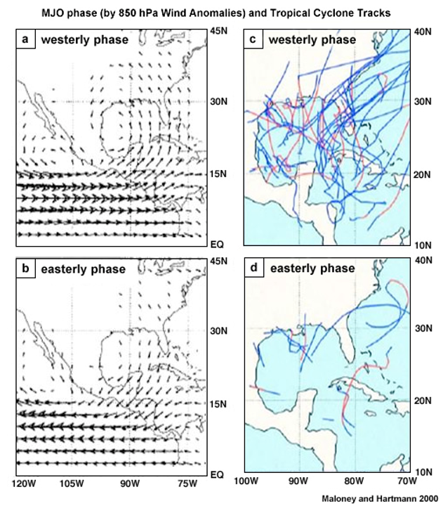
What phase of MJO increased frequency in tropical cyclones?
Active MJO