AP Environmental Science Unit 4 Guide: Atmospheric Systems and Climate
Earth's Atmosphere
The atmosphere is the blanket of gases surrounding Earth that is held in place by gravity. Understanding its structure and composition is critical because it dictates global temperatures, blocks harmful solar radiation, and drives weather events.
Composition of the Atmosphere
For the AP exam, you must memorize the relative abundance of the primary gases in the lower atmosphere (homosphere). This composition is generally uniform globally.
- Nitrogen ($N_2$): ~78% — The most abundant gas; largely unreactive.
- Oxygen ($O_2$): ~21% — Essential for respiration; produced by photosynthesis.
- Argon ($Ar$): ~0.9% — An inert noble gas.
- Trace Gases: <0.1% — Includes Carbon Dioxide ($CO2$), Methane ($CH4$), Ozone ($O3$), and Water Vapor ($H2O$). Despite their small percentages, these act as significant Greenhouse Gases (GHGs).
Structure and Layers
The atmosphere is divided into layers based on temperature gradients (how temperature changes with altitude). Remember the mnemonics: "The Smart Man Takes Elevators".
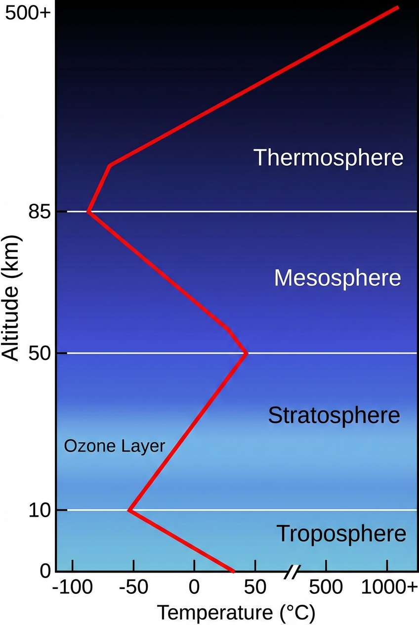
- Troposphere (0–10 km)
- Key Feature: Weather happens here. It contains 99% of the atmosphere's water vapor and 75% of its mass.
- Trend: Temperature decreases as altitude increases (moving away from the warmth of Earth's surface).
- Stratosphere (10–50 km)
- Key Feature: Contains the Ozone Layer ($O_3$), which absorbs harmful UV-B and UV-C radiation. Commercial jets fly here to avoid turbulence.
- Trend: Temperature increases with altitude (due to heat released during ozone formation/UV absorption).
- Mesosphere (50–85 km)
- Key Feature: Most meteors burn up here.
- Trend: Temperature decreases; this is the coldest layer.
- Thermosphere (85–600 km)
- Key Feature: The aurora borealis (Northern Lights) occurs here. It absorbs high-energy X-rays and UV radiation.
- Trend: Temperature increases drastically (can reach $1,500^{\circ}C$), though gas molecules are so sparse it wouldn't feel hot to human skin.
- Exosphere (600+ km)
- The transition zone into space where satellites orbit.
Solar Radiation and Earth's Seasons
Climate is fundamentally driven by the sun, but the heating is uneven across the globe. This uneven heating drives atmospheric circulation.
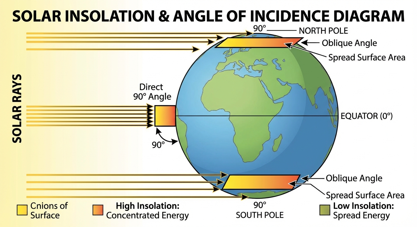
Incoming Solar Radiation (Insolation)
Insolation is the amount of solar radiation (energy from the sun) reaching an area measured in Watts/$m^2$.
- Angle of Incidence: The angle at which the sun's rays hit the Earth.
- Equator: Solar rays hit perpendicular ($90^{\circ}$ angle). The energy is concentrated on a small surface area $\rightarrow$ High Insolation.
- Poles: Solar rays hit at an oblique angle. The same amount of energy is spread over a larger surface area $\rightarrow$ Low Insolation.
The Cause of Seasons
The primary cause of Earth's seasons is the tilt of Earth's axis of rotation ($23.5^{\circ}$), not the distance from the sun.
- June Solstice: The Northern Hemisphere is tilted toward the sun. It receives more direct sunlight and longer days (Summer). The Southern Hemisphere experiences Winter.
- December Solstice: The Northern Hemisphere is tilted away from the sun. It receives indirect sunlight and shorter days (Winter).
- Equinoxes (March & September): The sun is directly above the equator. Both hemispheres receive roughly 12 hours of daylight.
Albedo
Albedo is the percentage of incoming sunlight reflected from a surface. It acts as a feedback loop for global temperature.
- High Albedo (High Reflection): Ice, snow, clouds. Surfaces stay cooler.
- Low Albedo (High Absorption): Dark asphalt, forests, open ocean water. Surfaces absorb heat and warm up.
Global Wind Patterns
The atmosphere moves heat from the equator toward the poles through convection variances and Earth's rotation.
Atmospheric Circulation Cells
Solar heating at the equator causes air to warm, expand, become less dense, and rise. This creates a band of Low Pressure at the equator. This rising air eventually cools, sinks, and creates bands of High Pressure.
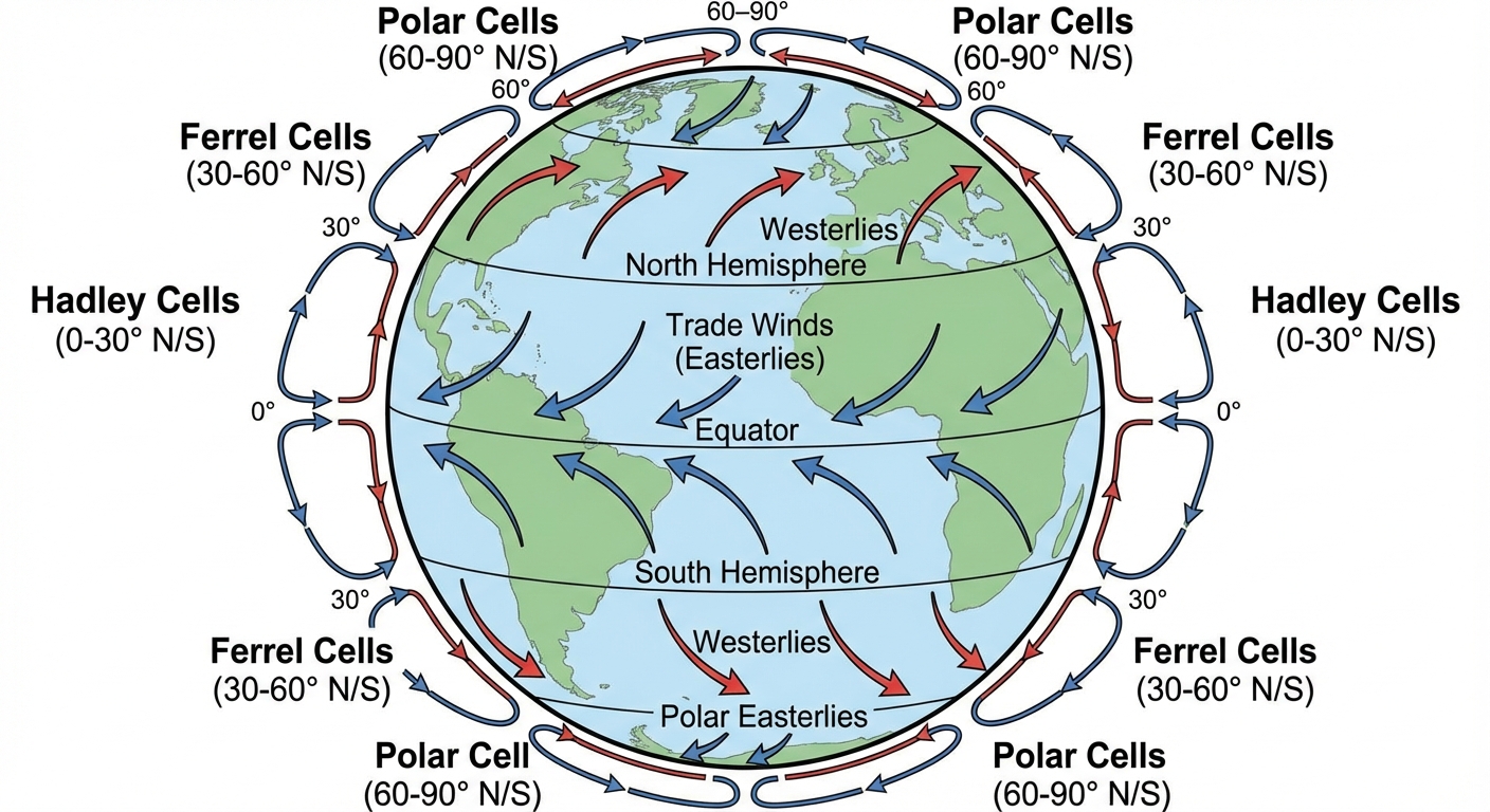
- Hadley Cells (0–30° Latitude):
- Warm air rises at the equator, moves poleward, cools, and sinks at $30^{\circ}$ N/S.
- Result: The sinking air creates hot, dry deserts at $30^{\circ}$ latitudes.
- Ferrel Cells (30–60° Latitude):
- Driven by the movement of Hadley and Polar cells. Air flows poleward near the surface.
- Polar Cells (60–90° Latitude):
- Cold, dense air sinks at the poles ($90^{\circ}$) and moves toward $60^{\circ}$, where it warms and rises.
The Coriolis Effect
The Coriolis Effect is the deflection of an object's path due to the rotation of Earth.
- Northern Hemisphere: Objects (winds) are deflected to the Right.
- Southern Hemisphere: Objects (winds) are deflected to the Left.
Prevailing Winds
Combining convection cells and the Coriolis effect gives us consistent wind patterns:
- Northeast Trade Winds: Blow from NE to SW (0–30° N).
- Westerlies: Blow from SW to NE (30–60° N). These drive weather systems across the continental US.
- Polar Easterlies: Blow from E to W (60–90°).
Earth's Geography and Climate
Local topography and proximity to water modify general climate patterns governed by latitude.
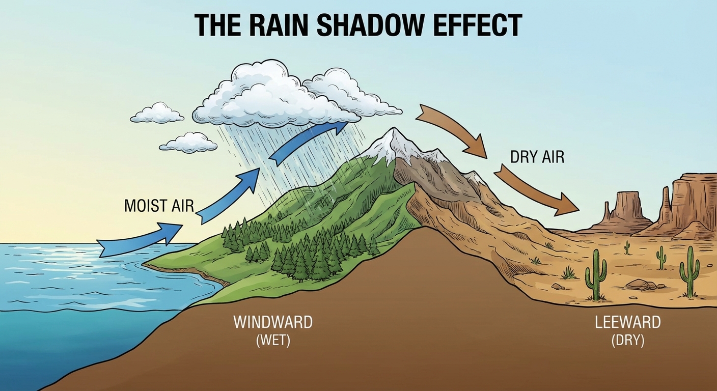
The Rain Shadow Effect
Mountains disrupt wind flow. When moisture-laden air hits a mountain range, it is forced upward.
- Windward Side:
- Air rises, cools, and condenses.
- Precipitation falls.
- Climate: Lush vegetation, wet (e.g., Seattle/Pacific Northwest).
- Leeward Side:
- Air descends, warms, and expands (Adiabatic heating).
- Moisture has already been lost.
- Climate: Arid, dry desert conditions (e.g., Eastern Washington, Death Valley).
Ocean Proximity and Specific Heat
Water has a much higher specific heat capacity than land, meaning it takes more energy to heat up and cool down water than soil/rock.
- Coastal Regions: Have moderate climates (cooler summers, warmer winters) because the ocean creates a thermal buffer.
- Inland Regions: Have more extreme temperature fluctuations (hotter summers, colder winters).
Lake Effects
In winter, cold air moving over varying warm bodies of water (like the Great Lakes) picks up moisture and drops heavy snow on the opposite shore (Lake Effect Snow).
Common Mistakes & Pitfalls
- Ozone Hole $\neq$ Global Warming: Students often conflate stratospheric ozone depletion (CFCs) with the greenhouse effect (Tropospheric $CO_2$). They are separate issues. The ozone layer blocks UV (preventing skin cancer); greenhouse gases trap heat.
- Season Misconception: Seasons are NOT caused by the distance between Earth and the Sun. Earth is actually closest to the sun (Perihelion) in January. Seasons are caused solely by the axial tilt.
- Coriolis Direction: Remember "Right in the North, Left in the South." A common error is flipping these directions.
- Pressure Flow: Wind always flows from High Pressure to Low Pressure, never the reverse.