Unit 4: Earth Systems & Global Water Dynamics
Watersheds and Drainage Basins
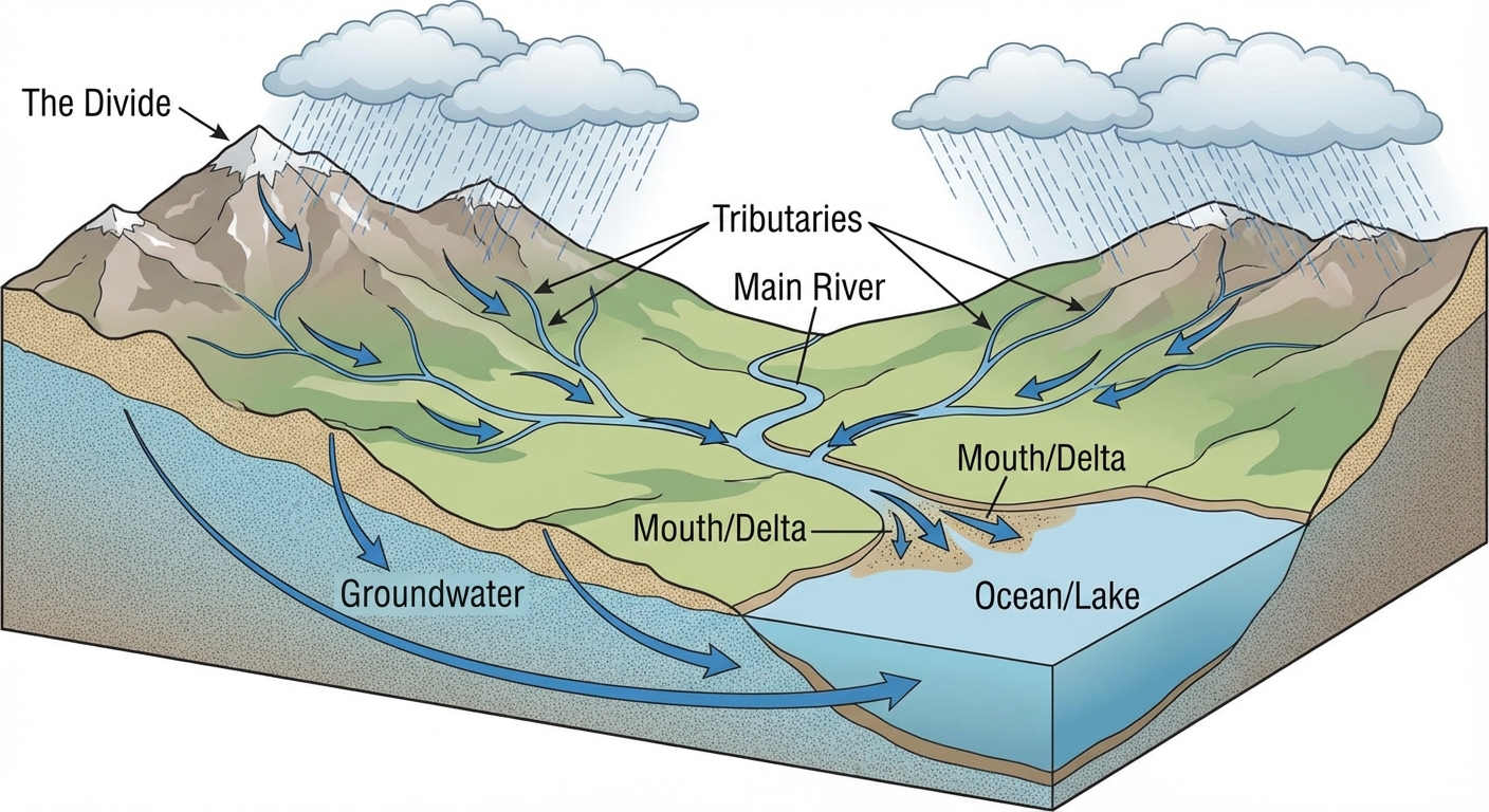
Defining the Watershed
A watershed (also known as a drainage basin or catchment) is a defined area of land where all surface water converges to a single point at a lower elevation, usually exiting the basin into another body of water such as a river, lake, or ocean.
Think of a watershed as a funnel. If you pour water anywhere inside the rim of a funnel, it all ends up at the bottom spout. In nature, the "rim" is the topographic high point.
- The Divide: The highest geographic points (ridges or mountains) separating one watershed from another. Water falling on one side of a divide flows into one basin; water falling on the other side flows into a different basin.
- Headwaters: The source geographic point of a river or stream.
- Tributaries: Smaller streams and rivers that flow into a larger main river.
- Mouth/Delta: The point where the river flows into a larger body of water (ocean or lake), often depositing sediment.
Characteristics of Watersheds
The physical properties of a watershed determine how water moves through it, which directly impacts water quality and ecosystem health:
- Area: A large watershed may hold more water but release it more slowly than a small one.
- Length & Slope:
- Steep slopes cause high velocity and high runoff, leading to increased soil erosion.
- Gentle slopes allow more time for water to infiltrate the soil (groundwater recharge).
- Soil Type:
- Sandy soils (high permeability) allow high infiltration and low runoff.
- Clay soils (low permeability) cause high runoff and low infiltration.
- Vegetation: Plants slow down runoff, anchor soil to prevent erosion, and filter pollutants.
Human Impacts on Watersheds
Humans alter the natural hydrology of watersheds primarily through development.
- Impermeable Surfaces: Pavement, parking lots, and rooftops prevent infiltration. This increases surface runoff volume and velocity, leading to flash floods and pollution (oil, trash, fertilizers) washing into streams.
- Deforestation: Removing trees destabilizes the soil, leading to sedimentation (turbidity) in rivers, which can suffocate fish eggs and block sunlight for aquatic plants.
El Niño and La Niña (ENSO)
The El Niño-Southern Oscillation (ENSO) is a recurring climate pattern involving changes in the temperature of waters in the central and eastern tropical Pacific Ocean. This cycle occurs irregularly every 2–7 years and has profound impacts on global weather, wildfires, and ecosystems.
In the context of the AP Environmental Science exam, you must understand the interaction between the atmosphere (trade winds), the hydrosphere (ocean currents), and the biosphere (fisheries).
Normal Conditions (Neutral Phase)
Before understanding the anomalies, you must understand the baseline.
- Trade Winds: Strong trade winds blow from East to West across the tropical Pacific.
- Ocean Surface: These winds push warm surface water toward the Western Pacific (Australia/Indonesia), where it piles up. Consequently, the sea surface level is actually higher in Indonesia than in South America.
- Upwelling: As warm water is pushed away from the coast of South America (Peru/Ecuador), cold, nutrient-rich water rises from the deep ocean to replace it.
- Ecological Impact: These nutrients support massive phytoplankton blooms, which support anchovy populations and a robust fishing industry.
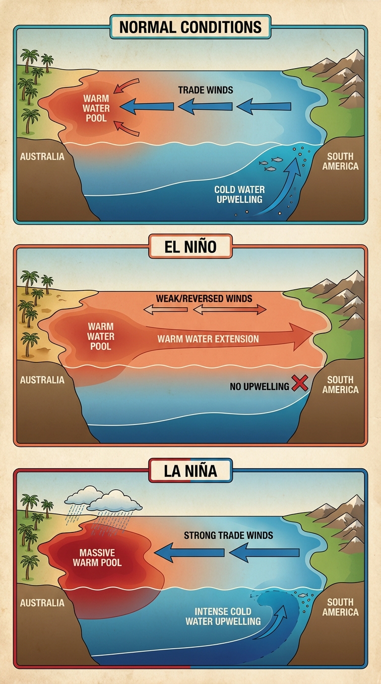
El Niño (The Warm Phase)
El Niño means "The Little Boy" (or Christ Child) in Spanish, named because it often peaks around Christmas.
- Atmosphere: The trade winds weaken or reverse (blow West to East).
- Hydrosphere: The warm water pool that was piled up in the West "sloshes" back toward the East (South America).
- Upwelling: The movement of warm water toward South America suppresses upwelling. The nutrient supply is cut off.
- Weather Impacts:
- South America: Warmer ocean leads to increased evaporation and heavy rainfall (flooding, landslides).
- Australia/Southeast Asia: The warm water leaves, causing cooler ocean temps locally, leading to drier conditions (droughts, high fire risk).
- North America: Often results in warmer, drier winters in the North/Canada and wetter, cooler winters in the southern US.
La Niña (The Cool Phase)
La Niña means "The Little Girl" and is essentially an intensification of normal conditions.
- Atmosphere: Trade winds become extremely strong, blowing aggressively East to West.
- Hydrosphere: Warm water is pushed even further West. The Eastern Pacific becomes unusually cold.
- Upwelling: Upwelling off the coast of South America is stronger than usual.
- Weather Impacts:
- South America: Drought conditions (very dry/cool).
- Australia/Southeast Asia: Massive evaporation from the accumulated warm water leads to heavy monsoons and intense flooding.
- North America: Associated with increased Atlantic hurricane activity; colder, wetter winters in the Pacific Northwest; and warmer, drier conditions in the southern US.
Summary of Global Impacts
| Feature | Normal Conditions | El Niño | La Niña |
|---|---|---|---|
| Trade Winds | Strong (East $\to$ West) | Weak or Reverse (West $\to$ East) | Very Strong (East $\to$ West) |
| Eastern Pacific Water (Peru) | Cool | Warm | Very Cold |
| Upwelling (Peru) | Present | Suppressed/None | Strong |
| South America Weather | Dry/Moderate | Flooding/Rain | Drought/Dry |
| Australia/Asia Weather | Wet | Drought/Fire | Flooding/Typhoons |
Mnemonics & Memory Aids
To distinguishing El Niño from La Niña, remember this phrase:
"El Niñ-NO"
- NO Wind (Trades weaken)
- NO Upwelling (Nutrients are gone)
- NO Fish (Fisheries collapse)
For La Niña, think "La Niña is MEAN-ya."
- She takes the normal conditions and makes them extreme (harsher winds, colder East Pacific).
Common Mistakes & Pitfalls
Confusing Weather with Climate:
- El Niño is a climate pattern (occurring over months/years), not a single weather event like a thunderstorm. However, it causes weather events.
The "Ozone" Confusion:
- Mistake: Students often claim El Niño is caused by Global Warming or Ozone depletion.
- Correction: El Niño is a natural, historical oscillation. While Climate Change may affect the intensity or frequency of ENSO events, it does not cause them.
Geography Mix-ups:
- Mistake: Thinking El Niño causes drought everywhere.
- Correction: It is a redistribution of rain. If it rains more in Peru, it must rain less somewhere else (Australia). Always pair the regions: (South America $\leftrightarrow$ Australia).
Watershed Boundaries:
- Mistake: Thinking political borders define watersheds.
- Correction: Watersheds are defined solely by topography (gravity). Water does not stop at a state line; this creates issues for management (e.g., pollution in the Mississippi River comes from 31 different states).