Unit 1: The Living World: Ecosystems
Introduction to Ecosystem Interactions
An Ecosystem is defined by the interactions between biotic (living) and abiotic (non-living) components in a specific area. Understanding these interactions is fundamental to Environmental Science. Species do not exist in isolation; they compete for resources (food, water, territory, mates) and form complex relationships.
Symbiotic Relationships
Symbiosis refers to a close, long-term interaction between two different species. In APES, you must identify how each organism is affected in the relationship.
| Relationship | Species A | Species B | Description & Example |
|---|---|---|---|
| Mutualism | $\mathbf{+}$ | $\mathbf{+}$ | Both species benefit. Ex: Coral and Zooxanthellae (algae), Bees and Flowers. |
| Commensalism | $\mathbf{+}$ | $\mathbf{0}$ | One benefits, the other is unaffected. Ex: Bromeliads growing on tree trunks (epiphytes) to reach sunlight. |
| Parasitism | $\mathbf{+}$ | $\mathbf{-}$ | One benefits (parasite) at the expense of the other (host). Ex: Ticks on a deer, Tapeworms in a broad. |
Competition and Resource Partitioning
When multiple species seek the same limited resource (interspecific competition), the species that is less efficient will eventually be excluded or forced to adapt. This concept is formalized in the Competitive Exclusion Principle.
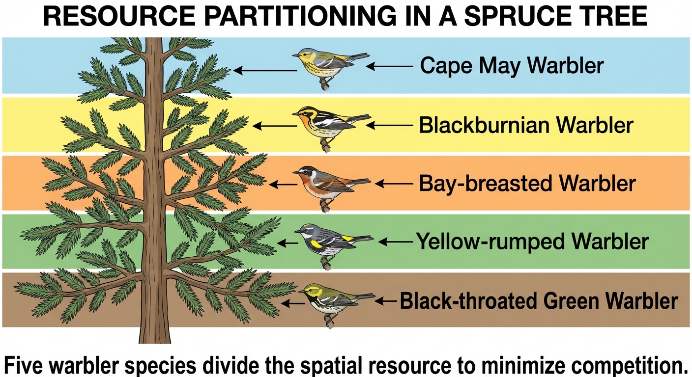
To avoid direct competition and extinction, species undergo Resource Partitioning—dividing resources to coexist. This can happen in three main ways:
- Temporal: Using resources at different times (e.g., wolves hunting by day, coyotes by night).
- Spatial: Using different areas of a shared habitat.
- Morphological: Evolving different body features to utilize different parts of a resource (e.g., Darwin's finches evolving different beak shapes).
Terrestrial Biomes
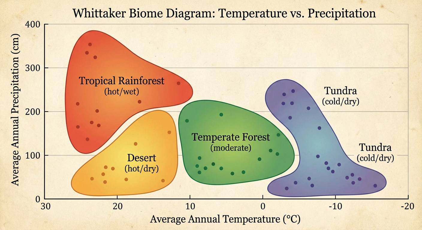
Biomes are large geographic regions defined by their dominant plant growth forms, which are determined by the area's climate. The two most critical abiotic factors determining a biome are Temperature and Precipitation.
Comparing Major Biomes
Global distribution of biomes follows potential evapotranspiration and latitude patterns.
1. Tropical Rainforest
- Location: Near the equator ($0^\circ$ to $10^\circ$ N/S).
- Climate: Warm and wet year-round.
- Key Feature: Highest biodiversity on Earth; distinct canopy layers.
- Soil: Nutrient-poor. Because decomposition is so rapid and vegetation uptake is so fast, nutrients do not accumulate in the soil.
2. Temperate Seasonal (Deciduous) Forest
- Location: Mid-latitudes (Europe, Eastern US).
- Climate: Warm summers, cold winters; moderate precipitation.
- Key Feature: Trees drop leaves in winter (deciduous).
- Soil: High nutrient availability due to leaf litter decomposition.
3. Taiga (Boreal Forest)
- Location: $50^\circ$-$60^\circ$ N (Canada, Russia).
- Climate: Cold winters, short growing season.
- Key Feature: Coniferous (cone-bearing) evergreen trees adapted to cold.
- Soil: Acidic and nutrient-poor (slow decomposition due to cold).
4. Temperate Grassland (Prairie/Steppe)
- Location: Mid-latitudes, continental interiors.
- Climate: Hot summers, cold winters; low precipitation prevents tree growth.
- Key Feature: Adapted to grazing and frequent fires.
- Soil: Most nutrient-rich soil in the world (high organic matter), making it ideal for agriculture.
5. Tundra
- Location: High latitudes ($60^\circ+$ N).
- Climate: Extremely cold, very low precipitation.
- Key Feature: Permafrost (permanently frozen subsoil) prevents deep root growth.
- Warning: Fragile biome; slow recovery from disturbances.
6. Desert
- Location: $30^\circ$ N/S.
- Climate: Precip $< 25$ cm/year; extreme temperature fluctuations.
- Key Feature: Plants have adaptations like water storage (succulents) and small surface area (spines) to reduce water loss.
7. Shrubland (Chaparral)
- Location: Coastal (SoCal, Mediterranean).
- Climate: Hot, dry summers; mild, rainy winters.
- Key Feature: Plants are fire-adapted (some seeds require fire to germinate).
Climatograms
In APES exams, you will analyze climatograms—charts that display monthly temperature (line graph) and precipitation (bar graph).
- Interpretation Rule: If the precipitation line is below the temperature line (when scaled $10^\circ C$ : $20mm$), plant growth is limited by water. If precipitation is above temperature, growth is limited by temperature (season).
Aquatic Biomes
Aquatic biomes are categorized by salinity, flow, and depth, rather than temperature and precipitation like terrestrial biomes.
Freshwater Biomes
- Streams and Rivers (Lotic):
- Flowing water originating from underground springs or runoff.
- High $\text{O}_2$: Rapidly flowing water mixes with air, resulting in high dissolved oxygen, supporting distinct fish species like trout.
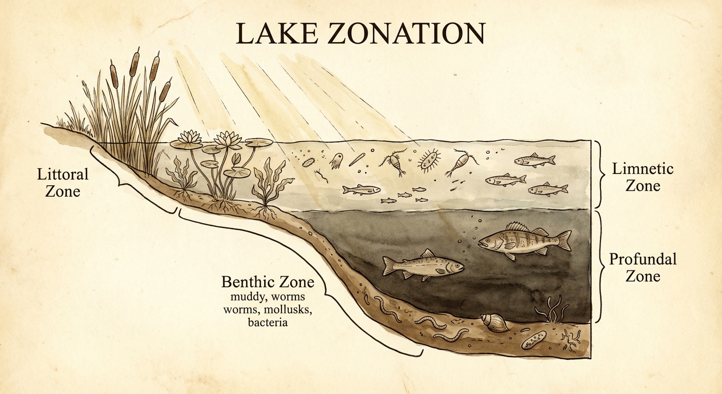
- Lakes and Ponds (Lentic):
- Standing water with distinct zones.
- Littoral Zone: Shallow edge, rooted plants emerge. High biodiversity.
- Limnetic Zone: Open water, sunlight penetrates. Dominated by phytoplankton ($Algae$).
- Profundal Zone: Deep water, no sunlight. Bacteria decompose matter $\rightarrow$ low oxygen.
- Benthic Zone: Muddy bottom, decomposers.
Marine Biomes
- Coral Reefs:
- Found in warm, shallow waters beyond the shoreline.
- Biodiversity: Most diverse marine biome.
- Threats: Ocean acidification and rising temperatures cause coral bleaching (expulsion of symbiotic algae).
- Open Ocean:
- Photic Zone: Top layer where sunlight allows photosynthesis.
- Aphotic Zone: Dark, deeper layer. Organisms rely on chemosynthesis or falling debris ("marine snow").
- Marshlands and Estuaries:
- Estuaries: Areas where freshwater rivers mix with saltwater oceans (brackish water).
- Ecological Services:
- Filtration: Plants filter pollutants and excess nutrients from runoff.
- Storm Protection: Absorb floodwaters and reduce storm surges.
- Nurseries: Provide habitat for fish reproduction.
Key Concepts: Resource Availability
In aquatic systems, productivity is rarely limited by water (obviously). Instead, it is limited by:
- Light: Decreases with depth.
- Nutrients: Specifically Nitrogen ($N$) and Phosphorus ($P$).
Common Mistakes & Pitfalls
- Weather vs. Climate: Students often confuse these. Weather is short-term; Climate is the average weather pattern over decades. Biomes are determined by climate.
- Misidentifying Soil Quality: A common error is assuming Tropical Rainforests have rich soil because of all the plants. The opposite is true—the soil is poor because the plants suck up nutrients immediately.
- Biome Shifting: When asked about climate change, do not say "the biome moves." Biomes are geographic classifications. Instead, say "the geographic range of the biome shifts towards the poles" or "conditions suitable for the biome move."
- Algae: Remember that algae (phytoplankton) provide the majority of Earth's oxygen, primarily from marine biomes, not rainforests.