APES Unit 4 Guide: Earth's Lithosphere and Soil Dynamics
Plate Tectonics and Geological Activity
The Earth's lithosphere (the rigid outer layer containing the crust and upper mantle) is broken into large pieces called tectonic plates. These plates float on top of the asthenosphere, a semi-molten layer of the mantle that flows slowly due to convection currents created by radioactive decay in the Earth's core.
Types of Plate Boundaries
The interaction between these plates drives geological events. The College Board focuses heavily on the three specific types of boundaries and the landforms created at each.
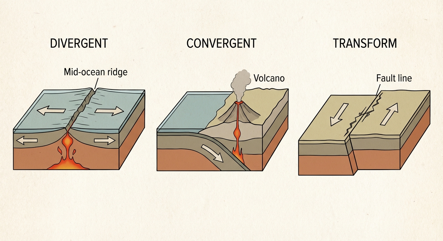
1. Divergent Boundaries
At divergent boundaries, plates move away from each other.
- Mechanism: As plates separate, magma rises from the mantle to fill the gap, cooling to form new lithosphere.
- Key Features: Seafloor spreading, rift valleys, volcanic islands, and mid-ocean ridges.
- Real-World Example: The Mid-Atlantic Ridge and the East African Rift Valley.
- Result: Earthquakes are common but usually less destructive than at convergent zones; creation of new crust.
2. Convergent Boundaries
At convergent boundaries, plates move toward each other. The result depends on the density of the plates involved.
- Oceanic-Continental: The denser oceanic plate is forced under the lighter continental plate in a process called subduction. This creates coastal volcanic ranges and deep ocean trenches (e.g., The Andes Mountains).
- Oceanic-Oceanic: The older, denser oceanic plate subducts. This forms island arcs and deep trenches (e.g., The Marianas Trench, Japan, Aleutian Islands).
- Continental-Continental: Neither plate subducts because both are buoyant. They crumple upward, creating massive non-volcanic mountain ranges (e.g., The Himalayas).
3. Transform Boundaries
At transform boundaries, plates slide past each other horizontally.
- Mechanism: Friction locks the plates in place; when the stress overcomes the friction, the plates slip, releasing energy.
- Key Features: Frequent earthquakes. No new crust is created or destroyed, and volcanoes are rare.
- Real-World Example: The San Andreas Fault in California.
Intra-Plate Volcanism: Hot Spots
Not all volcanic activity occurs at boundaries. A hot spot is an area where a plume of hot magma rises through the middle of a plate. As the plate moves over the stationary hot spot, a chain of volcanoes is formed.
- Example: The Hawaiian Islands (Pacific Plate moves over a hot spot).
Soil Formation and Erosion
Soil is not just dirt; it is a complex mixture of weathered mineral particles, decaying organic matter, water, air, and living organisms. It acts as a primary filter for water and a medium for plant growth.
The Process of Pedogenesis (Soil Formation)
Soil formation is a slow process controlled by five factors (mnemonic: CLORPT):
- Climate: Temperature and precipitation control the speed of weathering.
- Organisms: Bacteria, fungi, and worms break down organic matter and aerate soil.
- Relief (Topography): Slope affects erosion and sun exposure.
- Parent Material: The underlying rock determines the mineral content.
- Time: Soil takes hundreds to thousands of years to develop horizons.
Weathering vs. Erosion
It is vital to distinguish between these two processes:
- Weathering: The breakdown of rocks in situ (in place).
- Physical: Wind, rain, freeze-thaw cycles ($H_2O$ expands when freezing, cracking rocks).
- Chemical: Acid rain or oxidation dissolving minerals.
- Biological: Plant roots breaking rocks (lichen).
- Erosion: The physical removal and transport of soil fragments by wind, water, ice, or gravity.
Soil Horizons (The Soil Profile)
A mature soil profile is divided into distinct layers called horizons.
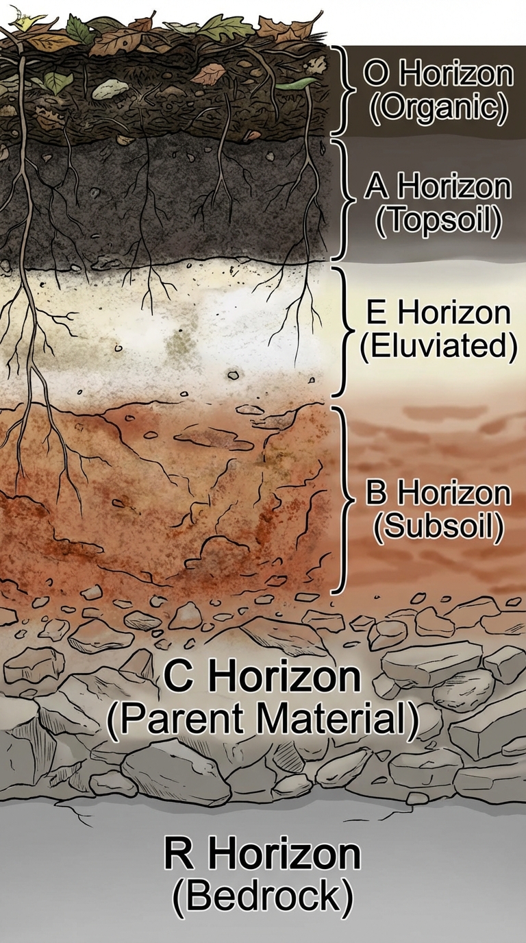
| Horizon | Name | Description |
|---|---|---|
| O Horizon | Organic | Surface layer of decomposing leaves and organic matter (humus). Thickest in forests. |
| A Horizon | Topsoil | Mixture of minerals and organics. The most biologically active layer; vital for agriculture. |
| E Horizon | Eluviated | The zone of leaching. Minerals and nutrients move downward from here leaving pale sand/silt. |
| B Horizon | Subsoil | Zone of accumulation. Minerals and nutrients leached from above accumulate here. |
| C Horizon | Parent Material | Weathered rock fragments with little organic material. |
| R Horizon | Bedrock | Unweathered solid rock. |
Memory Aid: Only Ants Eat Bread Crumbs Regularly.
Soil Composition and Properties
To assess soil quality for agriculture or construction, environmental scientists measure its physical and chemical properties.
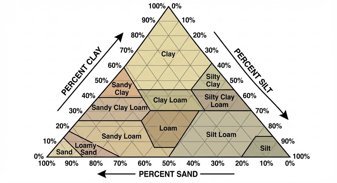
Soil Texture
Soil texture is determined by the percentage by weight of three particle sizes:
- Sand ($2.0 - 0.05mm$): Large particles, gritty. High drainage, poor nutrient retention.
- Silt ($0.05 - 0.002mm$): Medium particles, smooth.
- Clay ($< 0.002mm$): Microscopic particles, sticky. Poor drainage, high nutrient retention.
Loam is considered the ideal agricultural soil, consisting of roughly 40% sand, 40% silt, and 20% clay.
The Soil Texture Triangle
The texture triangle is a diagram used to classify soil based on these percentages. To read it:
- Find the % Sand on the bottom axis and follow the line angled up to the left.
- Find the % Clay on the left axis and follow the line straight across to the right.
- Find the % Silt on the right axis and follow the line angled down to the left.
The intersection of the three lines indicates the soil type.
Key Physical Properties
| Property | Definition | Relationship to Texture |
|---|---|---|
| Porosity | The volume of open spaces (pores) between soil particles. | Clay has the highest porosity (many tiny micropores); Sand has lower porosity. |
| Permeability | How rapidly water flows through the soil. | Sand has high permeability (large connected pores); Clay has very low permeability (waterlogging risk). |
| Water Holding Capacity | The ability of soil to hold water against gravity. | Clay holds water best; Sand dries out quickly. |
Chemical Properties
- pH: Affects nutrient availability. If soil is too acidic, heavy metals (like Aluminum) become soluble and toxic to plants. Remediated by adding lime.
- Cation Exchange Capacity (CEC): The ability of soil to attract and hold positive ions (nutrients like $Ca^{2+}$, $Mg^{2+}$, $K^+$). Clay and humus (organics) have high CEC, making them fertile.
Common Mistakes & Pitfalls
- Porosity vs. Permeability: This is the #1 student error. Students often assume that because clay is "tightly packed," it has low porosity. False. Clay has the highest porosity (most total air space) but the spaces are not connected, so it has low permeability (flow). Sand has lower porosity but high permeability.
- Weathering vs. Erosion: Do not use these interchangeably. Weathering happens in place (breaking); erosion is movement (taking).
- Tectonic Plates: Students often forget that "plates" include both the crust and the upper mantle (lithosphere), not just the crust.
- Reading the Triangle: When using the soil texture triangle, ensure you follow the grid line orientations. Remember: Sand flows Left, Clay flows Across, Silt flows Down (mnemonic: SLA - Sand Left, Clay Across…).
- O-Horizon: Not all soils have an O-horizon. It is prominent in forests but often absent in deserts or heavily tilled agricultural fields.