AP Environmental Science: Earth Systems and Resources
Unit 4: Earth Systems and Resources
4.1 Plate Tectonics
Structure of the Earth
To understand plate tectonics, you must first understand the Earth's layered structure. The Earth is differentiated by density.
- Core: The innermost zone. The inner core is solid iron and nickel (due to immense pressure), while the outer core is liquid molten metal (responsible for Earth's magnetic field).
- Mantle: The thickest layer, composed of molten rock (magma) that circulates in convection currents.
- Asthenosphere: The upper layer of the mantle. It is semi-molten or "plastic" (like soft clay), allowing the plates above to slide.
- Lithosphere: The cool, rigid, outermost layer. It includes the crust and the very top of the mantle. This is what breaks into tectonic plates.
- Crust: The brittle outer shell.
- Oceanic Crust: Thinner, denser, and made of basalt.
- Continental Crust: Thicker, less dense, and made of granite.
Plate Boundaries
Plate Tectonic Theory states that the lithosphere is divided into plates that float on the asthenosphere. The movement is driven by convection currents in the mantle (heat from the core causes magma to rise, cool, and sink).
There are three main types of interactions at the boundaries:
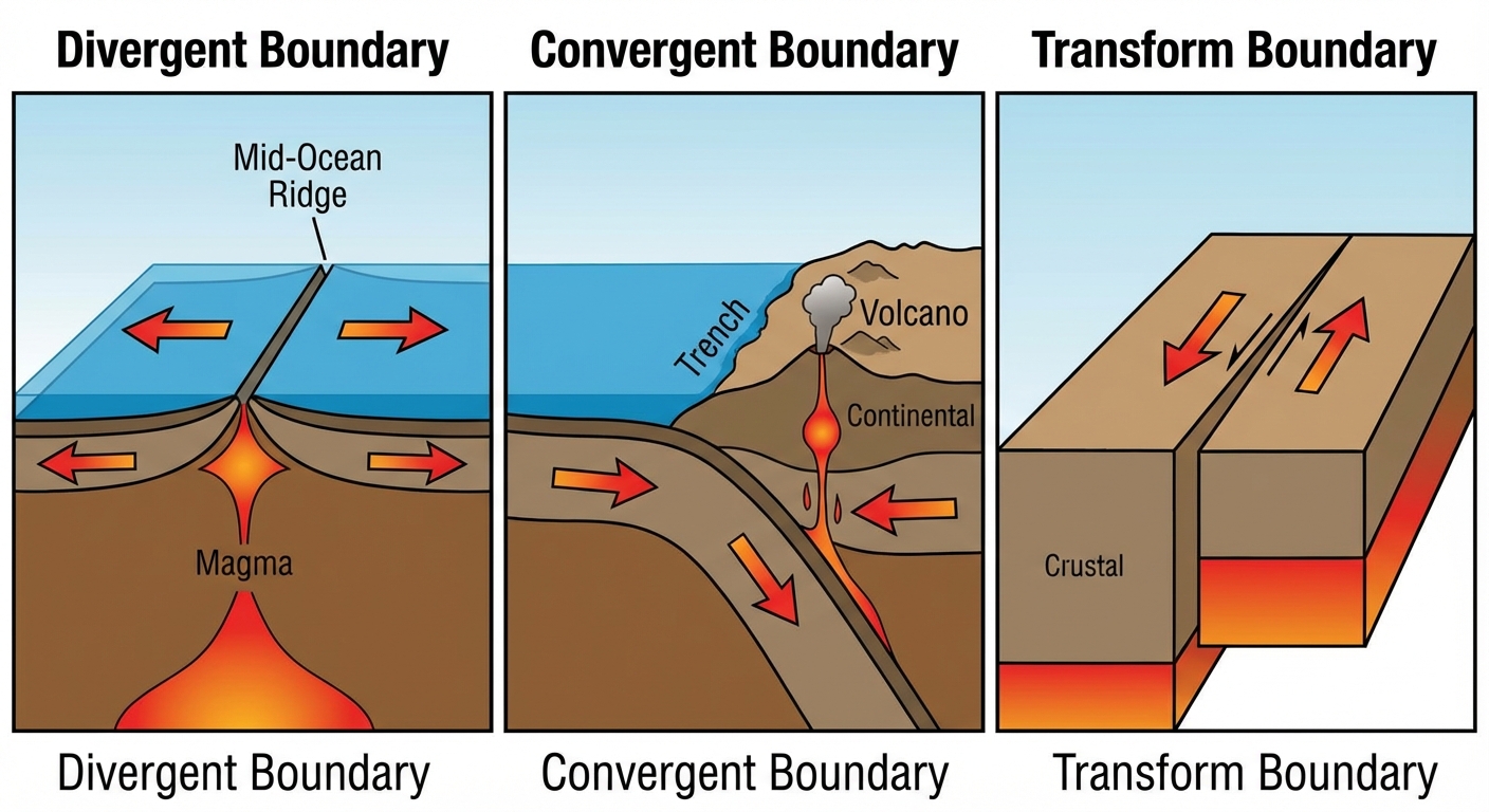
1. Convergent Boundaries
Occur where two plates collide (). The result depends on crust density.
- Oceanic-Continental: The denser oceanic plate sinks beneath the lighter continental plate in a process called subduction.
- Features: Deep ocean precipices (trenches), coastal volcanic mountains.
- Example: The Andes Mountains (Nazca plate moves under South American plate).
- Oceanic-Oceanic: The older, denser oceanic plate subducts.
- Features: Deep trenches, island arcs (chains of volcanic islands).
- Example: The Aleutian Islands or Japan.
- Continental-Continental: Since both plates are low density, neither subducts. They push upward.
- Features: Non-volcanic massive mountain ranges.
- Example: The Himalayas (Indian plate hitting Eurasian plate).
2. Divergent Boundaries
Occur where two plates move apart (). Magma rises from the mantle to fill the gap, creating new crust or lithosphere.
- Oceanic: Creates mid-ocean ridges and triggers seafloor spreading.
- Example: Mid-Atlantic Ridge.
- Continental: Creates rift valleys.
- Example: East African Rift Valley.
3. Transform Boundaries
Occur where plates slide past each other laterally. No crust is created or destroyed.
- Mechanism: Friction locks the plates; stress builds up until they slip, releasing energy as an earthquake.
- Example: San Andreas Fault (Pacific plate slides past North American plate).
Hot Spots
Sometimes, volcanoes form far from plate boundaries. A hot spot is a location where a stationary plume of hot magma rises through the mantle.
- As the tectonic plate moves over the stationary hot spot, a chain of volcanic islands is formed.
- Example: The Hawaiian Islands. The Big Island is currently over the hot spot, while older islands (Kauai) have moved away and are eroding.
Common Mistakes
- Mistake: Confusion between crust and lithosphere.
- Correction: The lithosphere includes the crust and the solid upper mantle.
- Mistake: Thinking divergent boundaries leave a hole in the Earth.
- Correction: Magma instantly fills the gap, cooling to form new rock.
- Mistake: Believing Tsunamis are caused by tides.
- Correction: Tsunamis are caused by underwater earthquakes (displacement of water), usually at subduction zones.
4.2 Soil Formation and Erosion
Soil Formation (Pedogenesis)
Soil is a complex mixture of weathered mineral particles, organic matter, air, water, and living organisms. It forms through weathering, the breakdown of parent material (rock).
- Physical (Mechanical) Weathering: Breakdown without chemical change (e.g., wind, rain, thermal expansion, freeze-thaw cycles).
- Chemical Weathering: Chemical reactions change the rock's composition (e.g., acid rain reacting with limestone).
- Biological Weathering: Tree roots or lichen breaking down rock.
Five Factors of Soil Formation:
- Parent Material: The bedrock type determines soil chemistry (e.g., limestone bedrock $\rightarrow$ calcium-rich soil).
- Climate: Temperature and precipitation control weathering rates (warm + wet = fast soil formation).
- Topography: Steep slopes have high erosion and thin soil; valleys have deep soil.
- Organisms: Bacteria/fungi decompose organic matter; worms aerate soil.
- Time: Soil formation is slow; it takes hundreds of years to form one inch of topsoil.
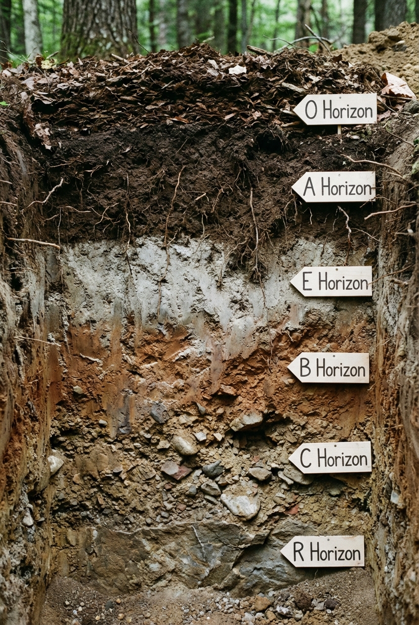
Soil Horizons (The Soil Profile)
A mature soil profile has distinct layers called horizons.
- O Horizon (Organic): Surface litter (leaves, organic debris). Provides nutrients.
- A Horizon (Topsoil): Humus (decomposed organic matter) mixed with mineral particles. Best environment for roots and microorganisms.
- E Horizon (Eluviation): Zone of leaching. Minerals and organic matter are "leached" (washed) down to the B horizon. Often pale in color.
- B Horizon (Subsoil): Zone of accumulation. Clay and minerals (iron, aluminum) from above gather here.
- C Horizon: Partially weathered parent material. Very little organic matter.
- R Horizon: Unweathered Bedrock.
Soil Erosion
The displacement of the upper layer of soil. While natural, human activity accelerates it.
- Drivers: Water (splash, sheet, rill, gully erosion), Wind, and Gravity.
- Human Causes: Deforestation, overgrazing, intensive tillage.
- Consequences: Loss of soil fertility, water pollution (sedimentation), increased flooding.
4.3 Soil Composition and Properties
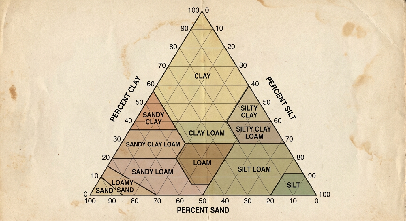
Soil Texture
Soil texture is defined by the percentage by weight of three particle sizes:
- Sand: Largest particle (). High permeability, low water retention.
- Silt: Medium particle (). Smooth floury feel.
- Clay: Smallest particle (<0.002\text{mm}). Low permeability, high water retention, high nutrient holding.
Loam is the ideal agricultural soil, roughly 40% sand, 40% silt, and 20% clay.
How to use the Soil Texture Triangle:
To determine soil type, you trace lines from the percentage of each component.
- Clay lines go straight horizontally (left/right).
- Silt lines go diagonally down toward the southwest.
- Sand lines go diagonally up toward the northwest.
Physical Properties
- Porosity: The volume of open spaces (pores) in soil.
- Permeability: How rapidly water flows through soil. (Sand = High, Clay = Low).
- Water Holding Capacity: How well soil retains water. (Clay = High, Sand = Low).
Chemical Properties
- pH: Measures acidity/alkalinity. Most plants prefer pH 6–7.
- Remediation: Add lime (calcium carbonate) to raise pH (fix acidity); add sulfur to lower pH.
- Cation Exchange Capacity (CEC): The ability of soil to hold positively charged nutrients (cations like , , ). Clay and humus have high CEC.
Common Mistakes
- Mistake: Assuming "clay" is always bad.
- Correction: Clay is essential for holding nutrients and water; too much causes drainage issues, but none leads to rapid drying.
- Mistake: Confusing porosity and permeability.
- Correction: Clay has high porosity (many tiny holes) but low permeability (holes are not connected well, so water flows slowly).
4.4 Earth's Atmosphere
Composition
The atmosphere is a mixture of gases held by gravity.
- Nitrogen (): ~78%. Inert gas.
- Oxygen (): ~21%. Produced by photosynthesis.
- Argon (): ~0.9%.
- Trace Gases: Carbon Dioxide () <0.04%, Methane, Ozone, Water Vapor.
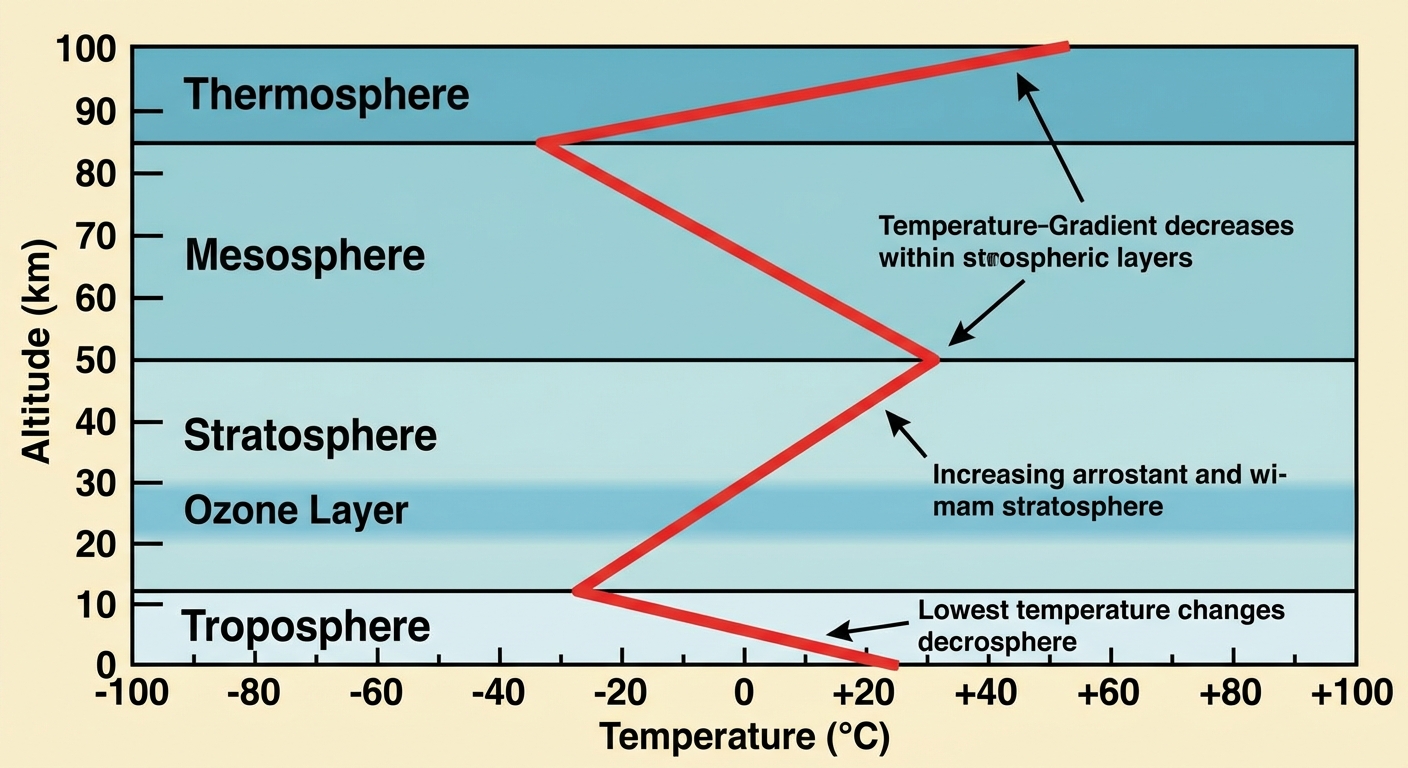
Layers of the Atmosphere
Layers are defined by temperature changes as altitude increases.
- Troposphere (0–10 km):
- Where weather occurs.
- Most dense layer (contains 75% of mass).
- Temperature: Decreases with altitude (further from warm Earth surface).
- Stratosphere (10–50 km):
- Contains the Ozone Layer () which blocks harmful UV-B and UV-C radiation.
- Temperature: Increases with altitude (ozone absorbs UV energy, creating heat).
- Mesosphere (50–85 km):
- Meteors burn up here.
- Temperature: Decreases with altitude (coldest layer).
- Thermosphere (85–600 km):
- Auroras (Northern Lights) occur here.
- Temperature: Increases drastically (absorbs high energy X-rays/UV) but feels cold due to low density.
- Exosphere: Transitions into space.
4.5 Global Wind Patterns
The Coriolis Effect
Because Earth creates a rotating frame of reference, free-moving objects (like air) appear to deflect from a straight path.
- Northern Hemisphere: Deflection to the right.
- Southern Hemisphere: Deflection to the left.
- Mechanism: The equator touches more space per hour (spins faster) than the poles. Air moving from equator to pole carries that faster momentum, appearing to move ahead of the ground.
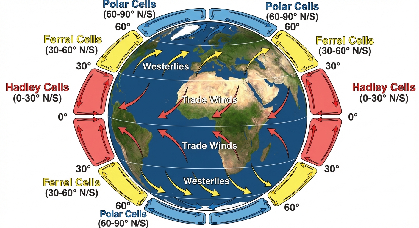
Atmospheric Circulation Cells
Uneven heating creates three major convection cells in each hemisphere:
- Hadley Cell (0°–30°):
- Warm air rises at the Equator (low pressure), cools, and sinks at 30° latitude (high pressure).
- Creates Rainforests at the equator (wet) and Deserts at 30° (dry).
- Ferrel Cell (30°–60°):
- Driven by the interaction of Hadley and Polar cells. Reverse circulation.
- Polar Cell (60°–90°):
- Cold air sinks at the poles and rises at 60°.
Prevailing Winds
- Trade Winds: Blow from East to West (Easterlies) between 0°–30°.
- Westerlies: Blow from West to East between 30°–60°. Major driver of US weather.
- Polar Easterlies: Blow from East to West between 60°–90°.
4.6 Watersheds
Definition
A watershed (or drainage basin) is a specific land area that drains water into a common river, bay, or other body of water.
Key Concepts
- Divide: The highest ridge of land (elevation) that marks the boundary between watersheds. Rain falling on one side goes to river A, on the other to river B.
- Tributaries: Smaller streams that feed into the main river.
- Delta/Mouth: Where the watershed empties into the ocean/lake. High sedimentation happens here.
- Groundwater: Watersheds include water percolating into aquifers below.
Human Impact
Since water flows downhill, pollution upstream impacts the entire ecosystem downstream.
- Agricultural Runoff: Fertilizers (Nitrates/Phosphates) cause eutrophication downstream (Dead Zones, e.g., Gulf of Mexico via Mississippi River).
- Urbanization: Impermeable surfaces (concrete) increase runoff volume and speed, leading to flash floods and decreased aquifer recharge.
4.7 Solar Radiation and Earth's Seasons
Insolation
Insolation = Incoming Solar Rationiation. It is the amount of solar energy (per ) reaching an area.
- Angle of Incidence: Sunlight hitting the Earth perpendicularly (90°) is most intense (Equator). Sunlight hitting at an oblique angle (near poles) is spread over a larger area and is less intense.
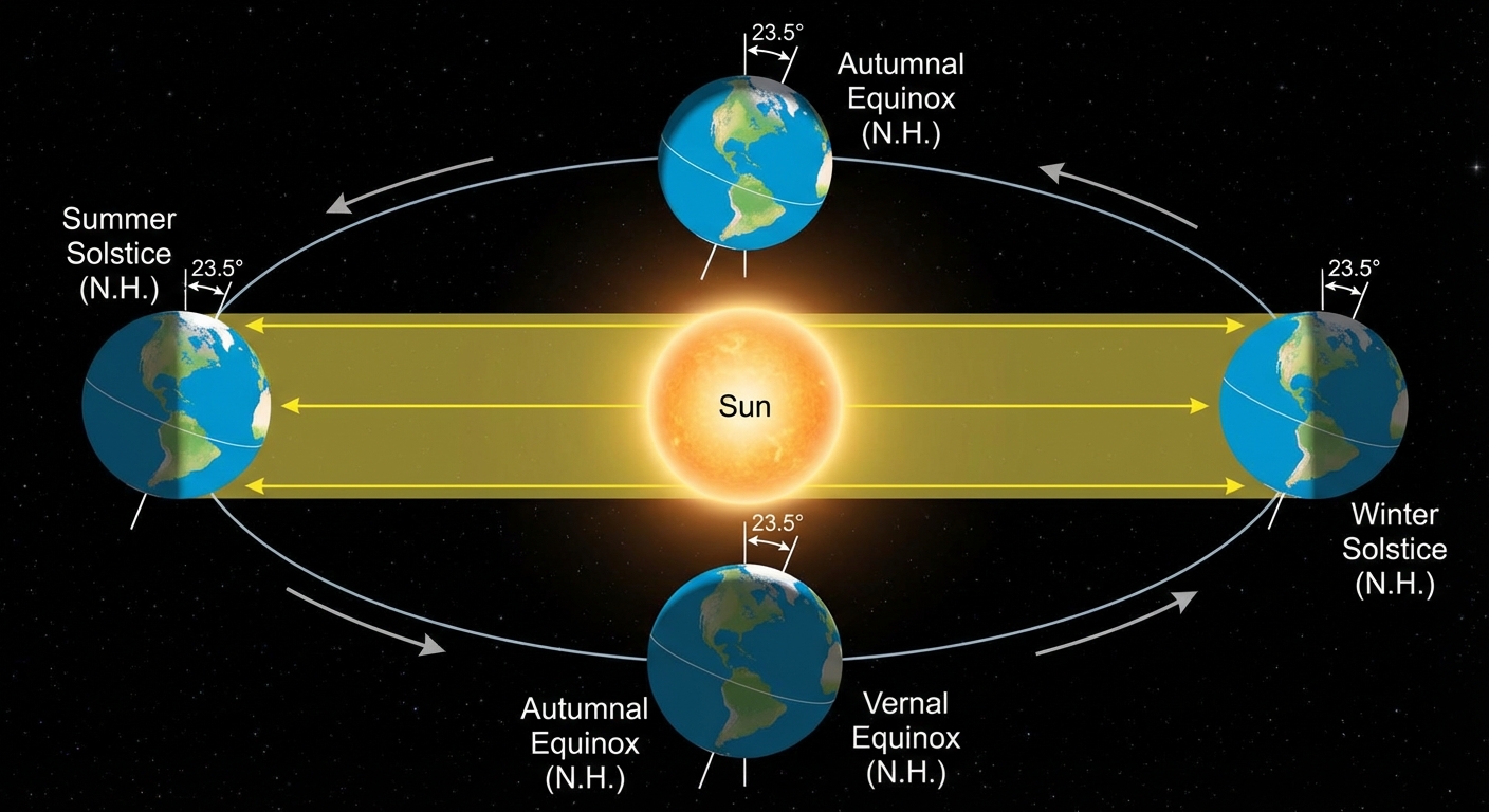
Reasons for Seasons
Seasons are NOT caused by the distance from the sun. They are caused by the tilt of Earth's axis (23.5°).
- June Solstice: Northern Hemisphere is tilted toward the sun. Longest day, highest insolation for the North (Summer).
- December Solstice: Northern Hemisphere is tilted away. Shortest day (Winter).
- Equinoxes (March/Sept): Sun is directly over the equator. Equal day/night length everywhere.
4.8 Earth's Geography and Climate
Weather vs. Climate
- Weather: Short-term atmospheric conditions (creates: "It is raining today").
- Climate: Long-term average patterns (30+ years) of temperature and precipitation (creates: "This is a tropical rainforest").
Rain Shadow Effect
Topography affects precipitation patterns.
- Windward Side: Moist ocean air hits a mountain, is forced up, cools, and condensates. Result: Heavy rain/snow and lush vegetation.
- Leeward Side: Air descends the other side. It is now dry and warms up, absorbing moisture from the land. Result: Arid conditions or deserts.
- Example: The Mojave Desert is in the rain shadow of the Sierra Nevada mountains.
Proximity to Water
Water has a high specific heat (it takes a lot of energy to heat up or cool down).
- Coastal areas: Have stable climates (cooler summers, warmer winters).
- Inland areas: Have extreme temperature fluctuations.
4.9 El Niño and La Niña (ENSO)
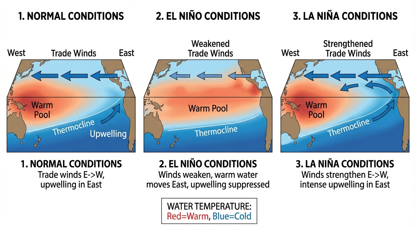
El Niño Southern Oscillation (ENSO) is a recurring climate pattern involving changes in the temperature of waters in the central and eastern tropical Pacific Ocean.
Normal Conditions (Walker Circulation)
- Trade winds blow East to West (South America $\rightarrow$ Australia).
- Warm surface water piles up near Australia/Indonesia (Rainy/Warm there).
- Upwelling: Cold, nutrient-rich water rises off the coast of South America (Peru) to replace the water pushed west. This supports massive fish populations.
El Niño (Warm Phase)
- Mechanism: Trade winds weaken or reverse.
- Result: Warm water flows back toward South America.
- Impacts:
- South America: Upwelling is suppressed (fisheries collapse). Heavy floods and rain.
- Australia/SE Asia: Droughts and increased fire risk.
- North America: Warmer, drier winters in the North; wetter, cooler winters in the South.
La Niña (Cool Phase)
- Mechanism: Trade winds become stronger than normal.
- Result: Even more warm water is pushed west. Increased upwelling in South America.
- Impacts:
- South America: Very cool and dry conditions.
- Australia/SE Asia: Intense flooding and monsoons.
- North America: More hurricanes in the Atlantic.
Common Mistakes
- Mistake: Thinking El Niño causes global warming.
- Correction: It causes temporary global warming spikes, but it is a natural cycle, not a result of anthropogenic greenhouse gases (though climate change may make it more intense).
- Mistake: Confusing the location.
- Correction: ENSO happens in the Pacific Ocean, between Australia and South America.